McLarty Treasure Museum

Cappy Z

Jr. Member
Jun 29, 2012
79
14
Atlantis
Primary Interest:
All Treasure Hunting
Here's a link with good info about the McLarty Treasure Museum.

McLarty Treasure Museum - Wikipedia, the free encyclopedia

f you ever get to Florida there is this small museum on the east coast. It was built on a survivors camp after a hurricane destroyed a treasure fleet. I am posting an aerial pic I think some folks might enjoy studying. The red circle is the museum. The white dots in the ocean are actual sites where treasure has been found. I personally believe that right under the beach near rock bottom is the mother lode. HH, Cap Z.
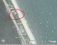
Motherlode#01.jpg
 

That's on my list, Cappy!

Hope I get there before I croak!
 

Hunted there for many years--first using a Relco then a Bounty Hunter. Use to cut thru that high ground before the museum was built. One of those houses is setting on land I tried to talk Dad into buying back when it was $40,000 (late 60's - early 70's). It was a few properties off the Real Eight cabin. Over the years I hunted there using a variety of other metal detectors--Whites, Garretts. Fishers and of course, Minelab. I was there after the hurricane about 6-8 years ago. Some of that high midden was washed out onto the beach, dumping prehistoric shell all over the place. Never had I found any evidence of spanish shipwreck treasure or artifacts at this location. But still, I too believe it exists in small amounts--most probably salvaged in 1715-16 and deposited in the bluff for safekeeping at Chuck's Steak House Salvage camp site. Giving consideration that Kip found cannons here just a few feet off the beach and in only 8-feet of water. Hence, wreck was shallow and easy to salvage soon after being wrecked. Local Indians salvaged much for themselves. The Dragon Pendant which was said in a certain book to be found on the beach, I learned from a reliable source that, it was actually found in the midden at the museum site or just a bit north near the campground entrance (another midden) on west side of A1A.
 

Last edited:
Southern digger:

When both the previous and the present inlets were dug, where did the dump the spoil from the digging??

billinstuart, Awhile ago I was MDing south of the inlet and watched as a man played in the sand with his kid. They had built a sand castle and he used his foot to scrape a mote leading to the ocean. I was amazed to see that only 6-8 inches down there was crushed shell...not sand. This was not a reef..it had been crushed. Could this be some of the spoil?
 

Last edited:
Southern digger:

When both the previous and the present inlets were dug, where did the dump the spoil from the digging??

This pertains to Jupiter Inlet, I presume. Previous inlet not dug--was natural; After 1840: new Inlet dug by Florida Vols. under command of Capt. Oscar Hart, brother to Florida Governor Ossian Hart. No fill removed manually. They dug a simple trench in location of present inlet, from what was then known as Jupiter River-thence, eastward thru the beach. The original Inlet was closed, in part, by the schooner wreck therein. Jupiter river filled with fresh water from the everglades (SW fork of the Loxahatchee). The water table in the river, being unable to flow out to sea,was higher than the ocean. The vols. broke thru to the river and a rush of water spilled thru the trench and down the beach. The force was so great that it deepened and widened the trench, forming a new inlet access. When was it first manually dug deeper?--not sure...--but first jetty dates to 1920's, so I Have read... small shell and gravel on Jupiter Beach was pumped in a recent renourishment project.
 

I agree with you Cappy Z. I think this will be true for most of the 16th century ships that wrecked within 500 feet of the present shoreline.

Many years ago Ron Becker, and I drilled and probed down 27 feet in the dune and hit Iron on the hard rock at the Cabin wreck Last year when I checked the beach south of Colored beach, for possible Treasure recovered and buried from what I thought may have been a fleet of 6 Portuguese ships wrecked just offshore, I was reading literally tons of Treasure & Cannon buried deep under the Beach sands. Dell

The same thing at Jupiter, Corrigans, and Sebastian, and south of the Power plant.

Dell, I believe that considering the history of the hurricanes and the accumulative effects of thixotropic layering there must be a treasure mound spread intermittently for miles. Kind of like how gold lines up in a gold pan after tapping. The truth is most metal detectors don't go deeper than 1-1 1/2 feet. heck, you can move that much sand with your foot! They don't call it 'heavy metal' for nothing. The key to accessing the mother lode is vertical detecting.
 

Actually, was referring to Sebastian. Originally there was "News cut"?, then the present location. Presently, ALL the inlets to the Indian river lagoon are man-made.

Bill,

Sorry about the misunderstanding. The question fit perfectly to a previous post I placed regarding Jupiter Inlet and I thought that is what you were referring too... However, regarding Sebastian Inlet area, I have never researched the historical aspects of where the original inlet, if any, existed. However, looking at the geological aspects, Florida had many seasonal inlets where rivers filled and spilled over into the ocean. Some of these low washouts, although sometimes dry, were referred to as haulovers. One such long closed inlet was in the Boca Raton area just at the north end of Spanish River park. Some historical references which I had seen in the past indicate this is one of the places that Ponced De Leon put ashore to obtain fresh water. I recommend you check the 1840-60's Coastal Surveys which can be seen on CIS series microfische at many larger public and university libraries. Good Luck.
 

The definition of insanity is to do the same thing over and over and Expect a different result.
So, through the last 50 plus years,thousands of people have metal detected the Treasure Beaches swinging perhaps a million hours over the same stretch of sand. And all the while their MD's only signaled at less than two feet, if that. On any given day the sand can roll one, two, three, or more feet creating a sculptured beach. This is exactly why many Treasure Hunters wait until a good storm or nor'easter moves the sand. But even then...only a few coins are found.

The mother lode of Treasure literally...is just beneath your feet. Still there...Still waiting...
 

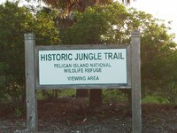
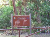
jungle trail.JPGI spent some time exploring the area and was amazed at what I found and what I encountered. The area I found most interesting was the Pelican Island National Wildlife Refuge! The very first one in our great countries history...coincidence...I think not...This area was famous for being the location of a local tribe of Indians who were well known for being water friendly or orientated...meaning they would dive and fish and make their livelyhood on and around the waters of the Sebastion inlet area. They were also known for trading the treasures that they found on the beach with the French and the British and The white man in general. I believe they disapeared abruptly and totaly without ever giving up their location of shipwreck artifacts recovered from the beaches...I think they were known as the Aisi Indians. Well I parked my truck at the parking lot by the boat launch...and by boat launch I mean canoe or kyak...there are signs posted that say do not go beond this point at the very immediate north end of the 6 car parking area. So I decided to follow the signs heading east tward the ocean and saw some fascinating things. I saw palm trees in an x, palm trees with perfectly cut round wholes in them, obveously made from some primative tools and done a long time ago. A pair of very stocky hardy short palms, but my favorite was the row of trees that went from the indian river almost to A1A. I have a friend who is of Panamanian decent and once lived in panama. He was very knowlegable of the local plants and trees and is a local river front resident. He was amazed at some odd tree formation I stumbled apon ...A row of perfectly lined up trees to my left, a row of perfectly lined up trees to my right extremley old and masive ...they created a natural corridor to rt. A1A.and the pin needle cover they created was incredable. My friend pointed out a few things to me after surveying the area. This corridor of trees was elevated above grade, there was a 5 foot deep trench running along side the entire corridor from Indian river to almost A1A. The road and boat ramp acted as a plug to keep these trenches from being flooded...AMAZING! If you were approaching this tree line from the north our south it would appear to be a small forest and not just a perfect row of very old trees with a hump in the corridor between them and a trench on both the north and south side of the trees. We also found some deliceous grapefruit trees and picked a bunch and headed back to the car after a couple hours of exploration...as soon as our feet hit the pavement in front of these trees, we were met by a pickup truck sporting a federal logo that was pelican island related...couldnt quite read it from the distance that he stopped and turned to block the road...a man got out of the truck in plain cloths with sun glasses and some kinda radio on his waist with an ear plug in one ear. He just looked at us and we looked at him for a secod before I whispered to my panamanian side kick...just start heading down the boat ramp and wash off the grapefruit and pay him no attention...well...he got back in his truck and stopped at the top of the ramp and when we turned around with our grapefruit and started heading for my truck he took off...Its a good thing I listened to my better judgement and left my excalibur 1000 in the truck with my shovels and other digging tools...pelican island.JPG
 

scubatreasure, The Florida mafia, I mean govt, treats you worse than the cartels. Florida has muscled- up GED grads for police.
For every MDer they nab, they get another tattoo. They like their power also. I once got in the face of one and his eyes lit up like a possessed monkey during mating season. I strongly recommend you not take chances and check out the law wherever you might used that MD. As a precaution, carry a few bananas in case you happen upon a 'peace' officer.
 

Bob, it was a seaeagle foldcat. I sold it after that adventure. Perhaps, it was the 5 mile walk that did me in? I wish the ranger drove by me, I would of had him drive me back. PM me and tell me whas sup with the Panama dude. Currently getting visions of sitting on his patio, watching a pond get drained while a front end loader digging heaps of sand creating mounds dotted all over his yard and your lazy arse in a hammock. Good times... rofl
 

Scuba:

If those were Australian Pines, they are invasives, planted by early pioneers as wind breaks for citrus groves. Even 50 years ago these trees were huge. They are very often planted in lines as they bordered property lines. I'll bet they run perfectly east and west, as this is how Florida land is divided. The only exception is land grants, which were perpendicular to the coast.
Bill is correct about the pines. That's what the early pioneers did.
I was born and raised in the area (about 13 miles north of the museum). The museum was not their when I grew up. That entire area has completely changed over the years. As a teenager we used to dive for lobster of the beaches, and I remember seeing boats (the same boats day after day). We never paid any attention to them, we were to busy surfing and diving - and I mean freediving. We didn't have no money to buy tanks and gear, but we still tore up the lobster. Always would see people using metal detectors all over the beach in that area.
I have seen that stretch of beach for miles in each direction stripped of sand with nothing but rock showing. People would be all over the place. So a few of us bought some old whites detectors(not knowing anything about them at the time), and hit the beach. Lots of falsing - lots of not being able to find the target - lots of cuss words.
So we started reading about detectors and sand and minerals, and saltwater, and, and, and, and. Well it payed off. It was great back in the day. I have seen a good bit of hardpan exposed about 2 years ago around the museum. Not like what is back then, but I was still surprised when we seen it, and yes we detected till the we hours in the morning with no luck. Back in the 70's and 80's beach conditions were prime, top of the line for finding items of all kinds. I have seen the sand come and go from the south jetty to way past the museum. Sometimes it was a challenge to retrieve the target with all the rocks exposed, and other times easy. Items could be found by eye sometimes also if one new what to look for.
THE GOOD OLE DAYS - I MISS THEM.
 

This might sound odd...but a friend told me that there are actually 'laws' on the books...limiting how deep you can dig on a beach. Anyone here at TN ever hear of this? :icon_scratch:
 

Top Member Reactions

Users who are viewing this thread

Latest Discussions

Back
Top