Looking for Info on: Camp Rigg

Camp Rigg
(1864 - 1870?), near San Jose
Located on the north-side of the Gila River at Aztec Canyon (or Valley).


GPS? General location? :happysmiley:

Maybe I can help you with this. There are a few confusing points perhaps you can clarify for me so I can see what I have in my files. First, you say it is near San Jose, yet the Gila River ends at the Colorado River in Arizona. Next, there is a Aztec railroad station stop south of the Gila River. There is also the Aztec Hills in this area. Also, the California Column, during the Civil War, used exclusively the Butterfield Overland Trail south of the river. It is true that they had many camps along this section, often they gave them names of noted officers.
Like I stated, with a little clarification, maybe I can help you.
I have mentioned Major Edwin R. Rigg a few times in my recently published book The Butterfield Trail and Overland Mail Company in Arizona, 1858-1861. He was in charge of the troops of the California Column who established camps along the trail in Arizona.
 

Last edited:
Gork seems you know the history of Arz. can you tell me who built the fort outside bumble bee?
 

Gork seems you know the history of Arz. can you tell me who built the fort outside bumble bee?

My area of knowledge is mainly the Butterfield Overland Trail in Arizona. My recently published book on the subject is being used as the primary reference for their study to make the trail a National Historic Trail. But, because of this I do get into peripheral areas of other historical subjects on Arizona.
I do have in my book collection Ghost Towns of Arizona published in 1970. This may be the book that started the rumor without a reference. The book states that there was a temporary cavalry post there in 1860.
One of the problems in historical research is how words are used. If the military sleeps on a certain spot for one night it is called a "camp." They would even sometimes name them for one of their officers. After this, some take that to mean there was a camp or fort built there when it was only a one night stop. I have used the military orders published in the War of the Rebellion and found that the California Column did this all along the trail. I have seen it many times that some writers confuse these one night camps with actual structures.
In 1860 there were only two forts in southern Arizona. They were Fort Breckenridge and Fort Buchanan. Both were abandoned at the beginning of the Civil War early in 1861. Historians have attributed many settlements and other American occupation along the Butterfield Trail when it was in service. But, none existed except the settlement of Tucson. Otherwise there was nothing but the twenty-six stage stations of Butterfield and the Pima Villages on the entire 400.57 miles of trail in Arizona.
I was just looking at a web site that lists the Forts and Camps in Arizona. It is full of historical holes, especially when it talks about the camps and forts on the trail. It even states that Fort Bowie protected the Butterfield Overland mail trail. This is false as the Fort was built after Butterfield closed the line.
Maybe I can help further clarify it if you can give me your source for the question.
Almost the entire basis for my book on the trail was based on throwing out references referencing references. I went mostly to actual government sources and first hand accounts of that period. It is the only way to sort out the large body of erroneous material on Arizona's history.
 

gork I have been to this fort many times it is built on top of a steep rise (hard climb) , has gun holes for defense is made of a shale type rock stacked 3 to 4 ft high great defensive in nature. rock was hauled from river bed 1/4 mile also has a shaft leading down but no tailings, below is a shaft with a wooden door. leads inward then up to daylight. This is the fort with the engraved cross carved into a large slab stone.(Jesuit in nature) embelished only 2 sides.? hard to make out from ground level. thanks
 

gork I have been to this fort many times it is built on top of a steep rise (hard climb) , has gun holes for defense is made of a shale type rock stacked 3 to 4 ft high great defensive in nature. rock was hauled from river bed 1/4 mile also has a shaft leading down but no tailings, below is a shaft with a wooden door. leads inward then up to daylight. This is the fort with the engraved cross carved into a large slab stone.(Jesuit in nature) embelished only 2 sides.? hard to make out from ground level. thanks

Sounds like a very interesting structure. Without historical references, I guess this can't be determined. If it were military, by the sounds of the extensive structure, it should be noted in military archives. It wouldn't be from the Civil War era since all military orders for Arizona were published in the War of the Rebellion. It sounds like it wasn't built strictly as a fort, but was built for other purposes and fortified. There are other examples of this in Arizona. Both the Apache Pass and Dragoon Springs stage stations were built primarily as stage stations but were fortified.
It almost sounds like it is an older structure associated with mining in the area. Again, without any historical reference, it can only be speculated on. Do you have any photos of this structure?
 

More info:
HISTORY OF ARIZONA, Volume III
CHAPTER X. POPULATION—EARLY SETTLEMENT—INDIAN TROUBLES.
From Page 270
I had gone to Camp Rigg to hurry up supplies when the order reached Maj. Blakeney, and when he marched back to Camp Rigg, I found my men with him. I immediately started for Ft. Goodwin to endeavor to get Col. Rigg to still send an expedition to Signal Mountain. The Colonel made an order for two companies to proteed to that place and operate against the Indians in conjunction with my command, and two days after left for Las Cruces, turning over the command of the Apache expedition to Maj. Joseph Smith, who found it impossible to fit out the expedition, owing to the excessive rains and consequent failure of some provision trains to arrive at the Fort. The streams were also swollen so that he feared it would be impossible to cross. The expedition was, therefore, abandoned, to my great mortification and chagrin. I remained six days at the Fort and during that time Mr. McCannon returned from his expedition to the eastward in the search of another Black River. A portion of my men concluded to return to Ft. Goodwin and obtain employment; two enlisted, and two remained in the hospital and with the balance, numbering when I reached Camp Rigg 54 men, I started for home. The River Gila was swollen by the rains and difficult to cross, and we did not reach Camp Rigg until the third day after leaving Ft. Goodwin, a distance of 40 miles. Leaving Camp Rigg the next day, we reached the old camp at Pinal Creek in a day and a half, and then followed our trail back by Grapevine Springs to Salt
[page 271]
[FONT=&quot]River and up Tonto Creek to near its head. Crossing the dividing ridge a distance of about ten miles, we struck the east fork of the San Francisco about ten miles below our former camp on that stream, then followed down the Rio Verde or San Francisco.[/FONT]

Still no closer to a location on the ground:BangHead:
 

More info:
HISTORY OF ARIZONA, Volume III
CHAPTER X. POPULATION—EARLY SETTLEMENT—INDIAN TROUBLES.
From Page 270
I had gone to Camp Rigg to hurry up supplies when the order reached Maj. Blakeney, and when he marched back to Camp Rigg, I found my men with him. I immediately started for Ft. Goodwin to endeavor to get Col. Rigg to still send an expedition to Signal Mountain. The Colonel made an order for two companies to proteed to that place and operate against the Indians in conjunction with my command, and two days after left for Las Cruces, turning over the command of the Apache expedition to Maj. Joseph Smith, who found it impossible to fit out the expedition, owing to the excessive rains and consequent failure of some provision trains to arrive at the Fort. The streams were also swollen so that he feared it would be impossible to cross. The expedition was, therefore, abandoned, to my great mortification and chagrin. I remained six days at the Fort and during that time Mr. McCannon returned from his expedition to the eastward in the search of another Black River. A portion of my men concluded to return to Ft. Goodwin and obtain employment; two enlisted, and two remained in the hospital and with the balance, numbering when I reached Camp Rigg 54 men, I started for home. The River Gila was swollen by the rains and difficult to cross, and we did not reach Camp Rigg until the third day after leaving Ft. Goodwin, a distance of 40 miles. Leaving Camp Rigg the next day, we reached the old camp at Pinal Creek in a day and a half, and then followed our trail back by Grapevine Springs to Salt
[page 271]
River and up Tonto Creek to near its head. Crossing the dividing ridge a distance of about ten miles, we struck the east fork of the San Francisco about ten miles below our former camp on that stream, then followed down the Rio Verde or San Francisco.

Still no closer to a location on the ground:BangHead:

That one is out of my league. It sounds like it is night be in New Mexico. I am only familiar with the 180 mile stretch from the Pima Villages to where it flows into the Colorado River. I have a lot of data on that area. I am pretty well lost otherwise. Sorry I couldn't help. Have you tried checking the military orders given in the War of the Rebellion? This is available on Google Books.
 

That one is out of my league. It sounds like it is night be in New Mexico. I am only familiar with the 180 mile stretch from the Pima Villages to where it flows into the Colorado River. I have a lot of data on that area. I am pretty well lost otherwise. Sorry I couldn't help. Have you tried checking the military orders given in the War of the Rebellion? This is available on Google Books.

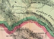
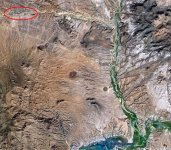
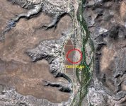
I found some info in files. Here is a sequence of three maps that should put you in the ballpark for Camp Riggs. I think some of the confusion is that in the orders they call it "Camp Rigg" and on the maps the call it "Camp Riggs." It is definitely it as it fits the distance description. Here is the sequence that should put you close. Note that the overall Google photo shows "Old San Carlos Rd" in the upper left which coincides with the 1864 map.

Camp Riggs-Map.JPGCamp Riggs-Google.JPGCamp Riggs-Google a.JPG
 

Last edited:
Hay Gork
Thanks for the help. I've get a place to look on the ground. Woo Hoo:thumbsup:

I might mention that I have and 1880 showing a "Munsons" on that spot. Looks like there may have been a homestead there later.
 

Top Member Reactions

Users who are viewing this thread

Back
Top