Lidar: The Best Resource for Relic Hunters

coinman123

Silver Member
Feb 21, 2013
4,659
5,769
New England, Somewhere Metal Detecting in the Wood
🥇 Banner finds
2
🏆 Honorable Mentions:
1
Detector(s) used
Teknetics T2 SE (DST)
Spare Teknetics T2 SE (backup)
15" T2 coil
Pro-Pointer
Bounty Hunter Pioneer 202
Fisher F2
Fisher F-Point
Primary Interest:
Other
I can't believe it, it feels way too easy using it. I just download data files from my state university website, unzip them with 7-Zip, and open them with FugroViewer. If there is any cellar hole, I can clearly see it, and will take a screenshot of the lidar map, save it, and overlay it in Google Earth. I thought it was too good to be true, and that the things on the lidar weren't really cellar holes. They don't appear on any historic maps from the 1850's onward. Sure enough, I went to some spots I found, and there was a pre-1850 cellar hole on each one (even one that was almost completely caved in). I prefer it to map overlays now, because I can find better cellar holes that were abandoned long before the map was made.
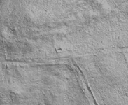
cellar.png
 

Theres some really good Lidars of some Brit sites showing Iron Age settlements, Roman roads, and whatnot. I never could seem to find any of the areas that I hunt. Good resource if you can make it work for you tho!
 

I doubt that is a cellar hole on that map.
Marvin
 

I doubt that is a cellar hole on that map.
Marvin

It might not be, I don't think I will ever be able to find out though. I realized that one is on a class vi road that may or may not be public or private, not going to take any chances though, going to check out confirmed public places first. I get less than a meter resolution, so a lot of smaller things show up too.
 

Last edited:
Thank you Coinman! I'm always looking for new research tools and appreciate you sharing. :icon_thumleft:
 

so where do you get these images? Im not tech savey. but love the idea of this
 

Top Member Reactions

Users who are viewing this thread

Back
Top