scrapmagnet
Jr. Member
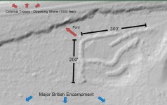
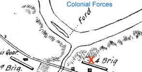
I stumbled upon this after looking at a British encampment map from the revolutionary war and getting curious. The surrounding area is heavily developed with the majority of the encampment area now covered by housing. This area, after looking at historical aerial photos, seems to be undisturbed and wooded.
These berms stand out like a sore thumb. I did read that the British did fire artillery on the colonials from this area. Is anyone familiar with the general design of British (shorter term) artillery fortifications? The only place that I could come up with to compare was the defenses at Valley Forge. Granted, Valley Forge was obviously not British, probably different ground/soil conditions and longer term. The Lidar does compare pretty closely as far as the thickness and height of berms after 250 years of erosion.
Note: The ford is outside of the image and the ridge across the top was raised to accommodate added transportation infrastructure.


