scrapmagnet
Jr. Member
I have a permission of about 10 acres. 1720s home and documentation of a previous wooden home. The original property was about 250 acres so the original house could be under a McMansion's yard.
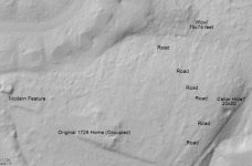
The area in the picture looks to have been a meadow with scattered trees in 1949 (historical aerial image) and is now fully wooded. I "seem" to have found both a road and a 75 foot square feature and possibly a cellar hole. Being that the woods are not extremely old, it is very dense in most spots and I'll need a machete to get to the spot. As excited as I am, I may try and wait until the leaves fall. There are a lot of easier areas to cover.
Does anyone with lidar experience have any idea of what I might be looking at?


