Late Ming and Early Ching Porcelain Fragments from Archaeological sites in Florida

Jolly Mon

Hero Member
Sep 3, 2012
868
631
Primary Interest:
All Treasure Hunting
Florida anthropologist


Take note: this issue is from 1955...previous to the discoveries of Wagner.

I would suggest the authors might have been mistaken about the genesis of some of the porcelain fragments.

The Higgs site was postulated to be a "pirate rendezvous". It is kind of funny, in retrospect.



florida porcelain fragments map.png

Of course this report is old, and oriental porcelain fragments have been found at MANY other sites, usually readily explainable as trade items or as the belongings of wealthy colonists. But early oriental porcelain fragments found in a relatively undeveloped coastal context might be indicative of a nearby shipwreck and not simply the remnants of trade or wealth. This is probably not a mind boggling hypothesis to many...but since porcelain is so much lighter than metal, it might well open the possibility of using the "Wagner methodology" in places it otherwise would be impossible. I do not believe a cob, lost in a wreck a mile offshore, stands much of a chance of ever making it into the surf zone. A piece of porcelain just might.

What the hell was oriental porcelain doing in a burial mound at Rookery Bay, for god sakes?
 

Last edited:
native indains carry off bits of plate from a shipwreck area for decorating reasons cuz its "pretty"
 

native indains carry off bits of plate from a shipwreck area for decorating reasons cuz its "pretty"

I believe that's the case.
I've seen them in exactly that context.
I always figured I'd see one with a hole drilled in it...actually surprised I haven't.
 

Last edited:
Wagner knew of the wreck and the porcelain at least as far back as 1950. His dragline operation was actually closer to the Higgs' site than the McClarty Museum. The latter is a half mile north of the original Higgs' site which was in the vicinity of Ambersand Beach Access. The Cabin Wreck site was actually solicited for salvage contract with the Internal Improvement Trust Fund in 1950 (check page 66 of my book "The Rainbow Chasers In The Great Florida Treasure Hunt").

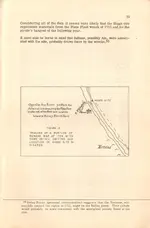
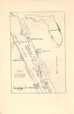
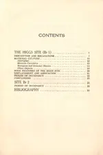
The Florida Anthropologist publication is not the only series of printed documents produced "officially" by Florida anthropologists, whomever they may be. I have included four pages from volume one of "Florida Anthropological Society Publications", which deals exclusively with the Higgs' site and another that was just to the south of it, now entirely washed away. In it, the obvious correlation between the Cabin Wreck and the porcelain is clear. Hale Smith, unlike many of his peers, was content to support Higgs' presumption that the things found were the product of European occupation resulting from the salvage. The boogyman showed up with the "tabby floor" construct discovered by Higgs. The problem seemed to be that there were other voices in the arguments that asserted this area to be an occupational site originally set up by Menendez or his immediate successors hundreds of years earlier. Archaeologist could not rectify their strata-based theory with the samples recovered in the layers where they were found, ergo, no final solution has ever been realized. Alas, as we have all said before, dynamic coastal zone archaeology should not rely on strata theory. The beach is subject to change. That's why it is possible to find a 32 slug next to a piece of eight, or pop-tops underneath minnie-balls. Hurricanes and inlets come and go. Hale Smith remarked that he found 10 feet of escarpment washed away in one year after Sebastian Inlet was finally opened.

Be aware that on the map showing Brevard County, that the Cabin Wreck site and the Higgs' site actually were in Brevard county at the time of the publication, as defined by the southern boundary latitude. The area was ceded to Indian River County in an agreement between Brevard and Indian River with the construction of the bridge over Sebastian Inlet on A1A.

As for Rookery mound, it is about the only high ground for many miles along the Keys coastline and there are many shipwrecks in the vicinity. No doubt the salvors would set up camp on the mound to escape high water and mosquitoes, as has been the case all along the coast in past centuries.
 

Attachments

  • 4.jpg
    4.jpg
    230.1 KB · Views: 265
  • 3.jpg
    3.jpg
    219.2 KB · Views: 239
  • 2.jpg
    2.jpg
    180.7 KB · Views: 182
  • 1.jpg
    1.jpg
    183.9 KB · Views: 181
Wagner knew of the wreck and the porcelain at least as far back as 1950. His dragline operation was actually closer to the Higgs' site than the McClarty Museum. The latter is a half mile north of the original Higgs' site which was in the vicinity of Ambersand Beach Access. The Cabin Wreck site was actually solicited for salvage contract with the Internal Improvement Trust Fund in 1950 (check page 66 of my book "The Rainbow Chasers In The Great Florida Treasure Hunt").

The Florida Anthropologist publication is not the only series of printed documents produced "officially" by Florida anthropologists, whomever they may be. I have included four pages from volume one of "Florida Anthropological Society Publications", which deals exclusively with the Higgs' site and another that was just to the south of it, now entirely washed away. In it, the obvious correlation between the Cabin Wreck and the porcelain is clear. Hale Smith, unlike many of his peers, was content to support Higgs' presumption that the things found were the product of European occupation resulting from the salvage. The boogyman showed up with the "tabby floor" construct discovered by Higgs. The problem seemed to be that there were other voices in the arguments that asserted this area to be an occupational site originally set up by Menendez or his immediate successors hundreds of years earlier. Archaeologist could not rectify their strata-based theory with the samples recovered in the layers where they were found, ergo, no final solution has ever been realized. Alas, as we have all said before, dynamic coastal zone archaeology should not rely on strata theory. The beach is subject to change. That's why it is possible to find a 32 slug next to a piece of eight, or pop-tops underneath minnie-balls. Hurricanes and inlets come and go. Hale Smith remarked that he found 10 feet of escarpment washed away in one year after Sebastian Inlet was finally opened.

Be aware that on the map showing Brevard County, that the Cabin Wreck site and the Higgs' site actually were in Brevard county at the time of the publication, as defined by the southern boundary latitude. The area was ceded to Indian River County in an agreement between Brevard and Indian River with the construction of the bridge over Sebastian Inlet on A1A.

As for Rookery mound, it is about the only high ground for many miles along the Keys coastline and there are many shipwrecks in the vicinity. No doubt the salvors would set up camp on the mound to escape high water and mosquitoes, as has been the case all along the coast in past centuries.

Good stuff. I read Pieces of Eight years ago and I guess I forgot the timeline.

Are you suggesting that artifacts recovered out of context might have limited archaeological value?? LOL. Just the thought must make university trained blue blood boil.

As for Rookery Mound, I suppose artifacts could well ( and probably did make it up from the Keys) , but it is also easy to imagine canoes sortieing out of Shark River to salvage a wreck in the vicinity of Ponce Bay. Talk about a shitty place to be shipwrecked...
 

Shut me up. I was thinking of the mound just north of the Holiday Isle on Windley Key. I'm all wet on that one. Where's Rookery at?
 

Well, you were close enough, probably.

Rookery Mound is on the Shark River, extreme southern west coast, just a little north of Cape Sable.

The porcelain could have gotten to the mound by several different routes, including trade or by simple seasonal movement of the Natives. The porcelain might well have its genesis in the keys.

Then again...
 

A bit off-topic, but, I saw some nice Seminole War soldier relics dug some 35 years ago from Middle Cape Sable, dug with the help of a park ranger... Items included musket balls; buttons; pieces of powder flasks; hat epaulettes and a few coins. Back then, some rangers were helping themselves at archeology sites--it was a sort of supplement to a poor paying job. I'm sure the mounds on Shark River were no exception. BTW--the soldiers and Florida Volunteers camped on some of these while reconnoitering the area in canoes and mackinaw boats.
 

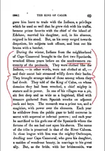
King Caloosa treasure.pngFrom France and England in North America, F. Parksman, 1880, pg. 69

The time frame of this tale is 1564 to 1565...long before the Atocha.
 

Last edited:
I would like to find that pit. There are wrecks in S.W. FL from Hernan Cortez's ships sailing back to Spain with treasure from Mexico starting in the 1540's.
 

I would like to find that pit. There are wrecks in S.W. FL from Hernan Cortez's ships sailing back to Spain with treasure from Mexico starting in the 1540's.

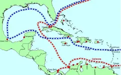
I think many people do not realize how far north the New Spain Fleet would travel into the gulf on its trip to Havana.

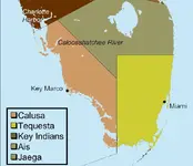
Interestingly, Calusa territory did NOT extend into the keys. It is hard to imagine a pit of treasure of this magnitude coming to the Calusa through trade with the Tequesta to the south. It is possible, I suppose, that they intruded upon Tequesta territory to salvage Spanish shipping losses, but there are simpler and more logical explanations.

Galleon Routes.pngCalusa Territory.png
 

"I think many people do not realize how far north the New Spain Fleet would travel into the gulf on its trip to Havana."

Oh yes, we know how far up in the Gulf they traveled. Don't forget the 1554 fleet sank off Padre Island, Texas. They followed the coastline from Vera Cruz to Havana. There are 8 galleons from the 1540's wrecked on Cape Romano shoals just below Key Marco.
 

I heard it from the archaeologist Rob Westrick, known here as Galleon Hunter. If he will publish his book we can all have a copy of the details.
Do you still represent the Cortez family?
 

View attachment 906327From France and England in North America, F. Parksman, 1880, pg. 69

The time frame of this tale is 1564 to 1565...long before the Atocha.

That'd be interesting.
16th Century was still so early in the exploration game, it's hard to determine if "southwest extremity of the peninsula" meant the same thing when a map of Florida was apt to look like this:

http://www.bigmapblog.com/maps/map03/EWJPmrqfKAAVsrzz.jpg

... as it does in todays era of full understanding.
 

That'd be interesting.
16th Century was still so early in the exploration game, it's hard to determine if "southwest extremity of the peninsula" meant the same thing when a map of Florida was apt to look like this:

http://www.bigmapblog.com/maps/map03/EWJPmrqfKAAVsrzz.jpg


... as it does in todays era of full understanding.

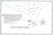
LM, Here's another Map that the Spanish Made in 1622 with some wreck sites. Looks like the Spanish didn't make very good Maps of Florida back then.
 

Attachments

  • CabezDeMartir.jpg
    CabezDeMartir.jpg
    32.9 KB · Views: 153

Top Member Reactions

Users who are viewing this thread

Back
Top