BosnMate
Gold Member
- Sep 10, 2010
- 6,916
- 8,441
- Detector(s) used
- Whites MXT, Whites DFX, Whites 6000 Di Pro
- Primary Interest:
- Other
Worldtalker has posted a couple of pictures taken before digital. That kind of kicked me in the butt to post a few of my slides from long long ago and far far away. Hope you enjoy them. This is the first few.

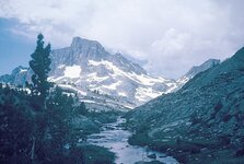
Back in 1959 or 60, I got a summer job packing mules in the high country of the southern Sierra Nevada. My memory isn't all that good anymore, but this picture is the outlet of a lake just below Banner or Ritter Mountain, I forget which one, and I forget the name of the lake. The elevation is timberline, 10,500 feet, the mountain is over 14,000 feet, and I would be taking the picture from the John Muir trail, sitting on my horse, a string of mules behind me. This is just south of Yosemite National park, and very close to being the very headwaters of the San Joaquin river.
The John Muir trail is part of the pacific crest trail, that travels through the high country from Mexico to Canada.

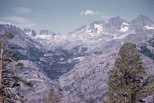
This is Shadow Lake, the picture is taken from a trail on the high bench on the east side of gorge of the middle fork of the San Joaquin River. This view is looking across the very deep gorge. You can see the white ribbon of water coming from the outlet of the lake. To the right of that stream you can see the trail through the solid granite. The trail takes you up to the outlet of the lake. The two peaks in the right hand horizon are Banner and Ritter mountains.

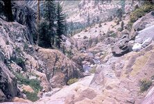
I'm sitting on my horse, on the above mentioned trail, the outlet of the lake is just right ahead.

Back in 1959 or 60, I got a summer job packing mules in the high country of the southern Sierra Nevada. My memory isn't all that good anymore, but this picture is the outlet of a lake just below Banner or Ritter Mountain, I forget which one, and I forget the name of the lake. The elevation is timberline, 10,500 feet, the mountain is over 14,000 feet, and I would be taking the picture from the John Muir trail, sitting on my horse, a string of mules behind me. This is just south of Yosemite National park, and very close to being the very headwaters of the San Joaquin river.
The John Muir trail is part of the pacific crest trail, that travels through the high country from Mexico to Canada.

This is Shadow Lake, the picture is taken from a trail on the high bench on the east side of gorge of the middle fork of the San Joaquin River. This view is looking across the very deep gorge. You can see the white ribbon of water coming from the outlet of the lake. To the right of that stream you can see the trail through the solid granite. The trail takes you up to the outlet of the lake. The two peaks in the right hand horizon are Banner and Ritter mountains.

I'm sitting on my horse, on the above mentioned trail, the outlet of the lake is just right ahead.


