Jesse James and the Horse and Saddle Map. What Do You Know About It?

LUE-Hawn

Sr. Member
Feb 16, 2018
401
347
United States
Detector(s) used
Minelab SDC 2300, Makro Deephunter Pro 3D, OKM EXP 4500 Pro, Garrett Hand Held Detectors, Falcon MD 20, English dowsing springs, Darley Spanish Dip Needle, L-Rods, what’s left of my brain :o)
Primary Interest:
All Treasure Hunting
attachment.php
 

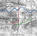
If you look at top (North) of the map you will see two letters m and c. This is Medicine Creek. It was known by that name in the 1870's as well as today.It is outlined in blue on both maps. This is your first clue as to the location.

The red line represents the old trail that was used for years and is a road today. There is still a road that crosses between the two mountains.

The long green line is giving the distance from the mountain to to the horse and saddle. It's 1.25 miles. Look at the bottom of the green line and you will see a tree with three lines coming out of the trunk. Now look at the area to the upper left of the horses head. Do you see those same three marks? Now follow the small green line to the left of the horse. Notice the tree and a long leg Y looking symbol on the mountain. These same symbols can be found at the top of long green line on the same map.

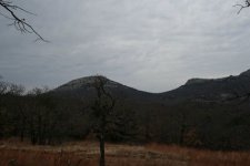
013.JPG
h_and_s[1].jpg
Horse_and_saddle 2.jpg
 

If you look at top (North) of the map you will see two letters m and c. This is Medicine Creek. It was known by that name in the 1870's as well as today.It is outlined in blue on both maps. This is your first clue as to the location.

The red line represents the old trail that was used for years and is a road today. There is still a road that crosses between the two mountains.

The long green line is giving the distance from the mountain to to the horse and saddle. It's 1.25 miles. Look at the bottom of the green line and you will see a tree with three lines coming out of the trunk. Now look at the area to the upper left of the horses head. Do you see those same three marks? Now follow the small green line to the left of the horse. Notice the tree and a long leg Y looking symbol on the mountain. These same symbols can be found at the top of long green line on the same map.

Hello Evans233,

Have you been there before and looked? You seem familiar with the area?

Regards

LUE-Hawn
 

i think he just pasted that info from the link that Randy posted earlier ;)

Yep that is what happened.

Still trying to navigate this system.

Regards

LUE-Hawn
 

Hi all of you,
Well I see you are working on ole Wells Blevin's map. Steve Wilson published this map in his Oklahoma Treasure and Treasure Tales, about 1980 I think. There have been many TH'ers trying to solve this puzzle but none but one has achieved success. The M.C. doesn't mean Medicine Creek The location has to remain secret but the loot is still there. If someone wanted to kill somebody just point them to that place. It's highly guarded by people you wouldn't want to mess with. It also has nothing to do with the horse and saddle cave mentioned by Joe Hunter. The map is legitimate and not that highly ciphered and works the same as all KGC maps. There are two maybe three coded companion maps showing where the individual caches are in this depository. BTW there is no proof to connect this map with JJ that is known. I see Randy B. has replied to the question. I'll bet Randy knows the person who deciphered this one too.
Someday, Someday Sooon. Be patient and you will learn a lot about treasure maps.
I know the story from my boss, Marta
 

evens223 my family lives at foot of Mt Sheridan east of gate going into refuge. I know that area pretty good. Looks like you are in New Mexico? Have you been out looking for this horse and saddle cave? I would like some more info on it. someone down the page said if you want someone killed send them to this cave!!!! I lived out that way for 35 years i know just about everyone and i am not scard about getting killed. My gun is as big as there gun lol. So if you would share some more info with me i'll look into it. Thanks.
 

778332.jpg

Hi Michael,
This site is a KGC site with more than one cache in the area. I don't want to give away any additional information right now as I may visit the area myself in the future.
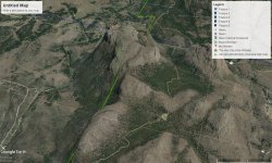
Here is a Google Map of the site area.
 

Let me know if and when you headed that way i will meet you we can look together if you need a partner. Like i said i know a lot of people around there most are my family. I remember going into Meers store and checking the mail when they still had PO boxes there back in 1970. My cousins live at foot of Mt Sheridan across the road right at gate going into refuge. I know that area pretty good. I sent you a pm
 

Hello All,

What do you guys and girls know about Jesse James and the Horse and Saddle Map. What Do You Know About It. Where is it located and has anyone found it? Please post your findings or clues to its existence and what have you found to verify it is where it is?

Thanks

LUE-Hawn

Lue, have you had any responses?

Liberty5601
 

Location of the real Jesse James treasure

I am new to treasure hunting and I've been studying about treasures recently when I went to. See my parents I seen a sign on a bluff and remembered this other place that had numbers on it anyway so I packed up for the tripand went solo cause everyone thought I was. Crazy. But. While I was there the first place I stop to look ended up being the all seeing eye sspot that the Spanish had left there and the every bluff you could see was shaped of an owlsome with crecents in there eye. And 1 had a king face and crown beside it so I went to it and low and behold I found it very dangerous though while I was there as soon as it got dark there were 4 drones on me. So I left but the was an all night situation but as I sit at the all seeing eye when morning came every hillside lit up with Jesse James the word mom it had images of two faces kissing any I found a silver Confederate ppl lol ate with JJ and kgc on it it was cut into a diff shape. But that night it was stolen by I'm assuming the drone controller and they been f**"ing with me ever since ... And u could only see Spanish signs at mid day I have the coordinates to this I need help no around here believes me. Ty
 

Look at the maps numbers and think latitude longitude the place I discovered is exactly as the map shows if any one is interested in helping me I will pm latitude and longitude of it's location
A
 

Look at the maps numbers and think latitude longitude the place I discovered is exactly as the map shows if any one is interested in helping me I will pm latitude and longitude of it's location
A

I am 5 miles from it now. I will be looking for the next several weeks. It is in no mans land but you can walk around trees. One comment up above says there are 2 maybe 3 companion maps that show were cashes are. Do yo know anything about that?
 

Hello Mr. Evens. I am 5 miles from it now. I will be looking for the next several weeks. It is in no mans land but you can walk around trees. One comment up above says there are 2 maybe 3 companion maps that show were cashes are. Do yo know anything about that?
 

Any ideal were I can find companion maps? I found the trees. are there markings on the trees?
 

Top Member Reactions

Users who are viewing this thread

Back
Top