West Jersey Detecting
Gold Member
I recently got an email from a new person to the hobby who asked if I would take him out and "show him the ropes". He said the oldest coin he had found to date was from 1937. I replied that I would be glad to take him detecting with me, but he should first consider what he can do to find the older stuff.
I explained that there were three factors that contribute to finding the "good stuff":
In this installment I will talk about how you can improve your odds with the help of research. More than 90% of my good finds come from research. I spend many hours analyzing old maps, aerial photos, Google Earth and historic documents to help me. This research allows me to maximize my time detecting, without spending a lot of time driving around looking for a good spot.
One of the greatest research tools is historic maps especially topographic maps. Old Insurance maps Such as the Sanborn fire maps (1867-1970) are very good as well. There are many online resources for finding these historic maps. The Digital Sanborn Maps are available at http://sanborn.umi.com/. email me for the password. My favorite is Maptech http://historical.maptech.com/index.cfm?CFID=5067896&CFTOKEN=48440713. Maptech has a fantastic collection of historic maps going back from the late 19th century through the mid 20th century.
The historic maps are useful when comparing to the terrain as it appears today. Terraserver-USA (http://terraserver-usa.com/) allows users to browse recent topo maps, as well as aerial photos. By comparing older topo maps with modern maps, you are able to see where structures were in the past, and what the site looks like today.
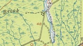
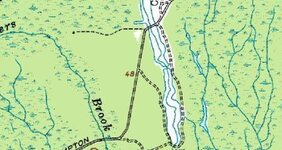
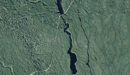
The three images below represent a site not far from my home. The first image is from a topo map from the 1940's. The five black squares are structures, possibly a small village. It may also be the remains of what may have been a larger village in the past. The next image is a 1972 image of the same site showing only one structure. The aerial photo shows the area as it appears today, with nothing remaining. Although these maps do not necessarily mean there will be buried treasure at the site, it will increase the odds of finding some older coins and silver.
In my next installment I will discuss how you can take these images and maps, and incorporate them into a Google Earth for precisely pinpointing locations.
I explained that there were three factors that contribute to finding the "good stuff":
- Knowing you machine- Become an expert at using your detector. Read the manual, cover to cover, and then go back and do it again.
Research- Know where you are going and what you are looking for. What was there in the past?
Luck-All you have to do to find the good stuff is walk over it.
In this installment I will talk about how you can improve your odds with the help of research. More than 90% of my good finds come from research. I spend many hours analyzing old maps, aerial photos, Google Earth and historic documents to help me. This research allows me to maximize my time detecting, without spending a lot of time driving around looking for a good spot.
One of the greatest research tools is historic maps especially topographic maps. Old Insurance maps Such as the Sanborn fire maps (1867-1970) are very good as well. There are many online resources for finding these historic maps. The Digital Sanborn Maps are available at http://sanborn.umi.com/. email me for the password. My favorite is Maptech http://historical.maptech.com/index.cfm?CFID=5067896&CFTOKEN=48440713. Maptech has a fantastic collection of historic maps going back from the late 19th century through the mid 20th century.
The historic maps are useful when comparing to the terrain as it appears today. Terraserver-USA (http://terraserver-usa.com/) allows users to browse recent topo maps, as well as aerial photos. By comparing older topo maps with modern maps, you are able to see where structures were in the past, and what the site looks like today.
The three images below represent a site not far from my home. The first image is from a topo map from the 1940's. The five black squares are structures, possibly a small village. It may also be the remains of what may have been a larger village in the past. The next image is a 1972 image of the same site showing only one structure. The aerial photo shows the area as it appears today, with nothing remaining. Although these maps do not necessarily mean there will be buried treasure at the site, it will increase the odds of finding some older coins and silver.
In my next installment I will discuss how you can take these images and maps, and incorporate them into a Google Earth for precisely pinpointing locations.


