ID Help from a Mountain Hunt and Some Notes on Campsites

GrouseMan

Jr. Member
Mar 2, 2020
64
154
Primary Interest:
All Treasure Hunting
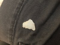
Went on a lengthy mountain hunt today and walked away with a scraper/graver, a broken tip, a ton of flakes, and this point. I've always wanted to find one serrated. It's got a broken tip and a broken ear. You may need to click the image to see it larger. Any idea what type of point this would've been and age/date? NC mountains.
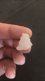
ArrowheadMountain2.PNG


I found atleast three campsites up there. And I'm starting to notice a pattern. Most of the campsites I find, both at this location and others in the area, are on saddles, or the ridgeline between two peaks. Anybody else notice this trend?
 

Attachments

  • ArrowheadMountain.jpg
    ArrowheadMountain.jpg
    557.9 KB · Views: 98
Last edited:
Upvote 0
The early archaic era saw massive earth changes -- particularly floods and rivers re-routing. Thus it seems no coincidence that EA points used to be called, many years ago, "mountaintop archaic" from being found on high elevations. As in your case, it seems. FWIW.
 

I assume the point is a triangle? Two possible types of small serrated triangles to check out would be Caraway and Fort Ancient. These are NC types.
 

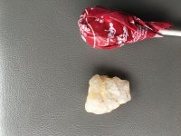
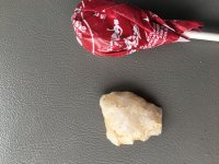
IMG_6801.JPGIMG_6802.JPG
This is as close as I have to that one. Its beat up but you can see some serration. The base is different. And yes, the saddles are productive areas.
 

Never heard about checking the saddles and this is second time on here in a week or so where someone mentioned archaic points as being mountain top points....I think almost every piece I?ve found in my 18 months at it here, have been identified as most probable archaic stuff....and my finds have come from cliff rock houses and overhangs on the high up sides of mountaintops following the big creeks ....I will be looking for ridge spots between two big tops now. Thank you folks as always. Knowledge is a tool
 

You hunting in Appalacia the oldest mountains in the world? I imagine there are many campsites. What I have always noticed just like in hunting you have a west wind and would camp accordingly.Sometimes a hump or ridge will block that wind where it cuts over it. Imagine lots of quartz was to be had.No idea on the broke but never hurts to dig if you can where you find flakes and charcoal.
Good luck!
 

With it being summer, now is a good time to find those old springs that don't run dry and are located close to a nice spot to camp--especially once it hasn't rained in a while.
 

My two cents, I’d imagine without much agriculture in the archaic there was less need to be down low with the mosquitos, and higher spots would also be useful in spotting game… I also wonder if it’s also to do with site exposure, maybe the archaic sites are buried in the lowlands and it is causing a site bias towards your saddles.
 

Alluvial burial -- in places -- is a definite factor.

IMHO, Mosquitos were probably not as much a factor in site selection as "How far do I have to walk to get a drink of water ?"
 

Ha you’re probably right about the mosquitoes, maybe it’s just because around here there is clouds of them, never seen them this bad, guess I’ve got them on the brain after being chewed up in the woods. at any rate it’s an interesting observation personally I love the why part of this hobby and trying to tease out every bit of knowledge from each find.
 

You hunting in Appalacia the oldest mountains in the world? I imagine there are many campsites. What I have always noticed just like in hunting you have a west wind and would camp accordingly.Sometimes a hump or ridge will block that wind where it cuts over it. Imagine lots of quartz was to be had.No idea on the broke but never hurts to dig if you can where you find flakes and charcoal.
Good luck!

I always try to keep in mind my hunters perspective. Problem on my problem is we are top of the watershed here. Water spring s up outta the ground in many places, this water rolls down the hillsides through the fields and into the creeks..who eventually feed to the lakes. So I am surrounded with mountainous, hilly steep terrain with lots of internal creeks feeding into main creeks that surround the property. There are so many areas for great hunting and camping. Guess that?s why I stick to the cliffs and the old inhabited overhangs. It?s most obvious place for me here to look. Creeks are a crapshoot with no context, random chance. The potential camp spots are everywhere here, so until I stumble over some fire rock and chert cores in the woods, I will continue to look in the overhangs and rock houses of the cliffs above the waters. Great discussions on here thanks
 

You could probably narrow it down some by focusing on Southern exposures &/or SE/SWestern ones. Way warmer in wintertime.

FWIW
 

I’ll also add this—I’ve hunted larger islands (30 acres+) on rivers here in va and nc and if the island itself doesn’t have a good spring, then know I will not find as much. In my mind Natives weren’t drinking out of major creeks and rivers for the same reason we don’t do so today—even if it’s a pretty spot to camp—and instead favored a good ole running spring. Find the good drinking water and a good place to camp
 

I always try to keep in mind my hunters perspective. Problem on my problem is we are top of the watershed here. Water spring s up outta the ground in many places, this water rolls down the hillsides through the fields and into the creeks..who eventually feed to the lakes. So I am surrounded with mountainous, hilly steep terrain with lots of internal creeks feeding into main creeks that surround the property. There are so many areas for great hunting and camping. Guess that?s why I stick to the cliffs and the old inhabited overhangs. It?s most obvious place for me here to look. Creeks are a crapshoot with no context, random chance. The potential camp spots are everywhere here, so until I stumble over some fire rock and chert cores in the woods, I will continue to look in the overhangs and rock houses of the cliffs above the waters. Great discussions on here thanks

Quinn same here. With all the rain the water table gets full and it shoots out the mountains. I can ride to the top and a spring will be blowing water the next day it has stopped but the ones below it will still be running and so forth. I think its all water pressure from below and limestone caves that cause that. The valleys flood. What has helped me is finding historic or ancient stream beds that comes from a spring. I have a civil war map and it showed a spring on it in at the base of a mountain. I went and found the spring and hiked the creek and found it had twisted and turned through several site and it yielded Bentons and some paleo. My guess is that spring has been pumping water from that mountain for a couple thousand years. So maybe the deep cut year round water sources up there might have some finds in them. The journey is always a fun one.
Oh yeah also found a small trickle on a rock face on the side of a bluff and found some points by it. That was 30 years ago and went by it last year and it was the same trickle out of the rock face.I was hiking an edge looking for over hangs. Like Uni said water is key.Good luck!
 

Many Monongahela/Fort Ancient sites are on saddles and all had a good spring very close by. If you know of a spring near a ridge top you will find artifacts by it, just a good spot to take a rest and get a drink.
 

When I was a kid the well water we drank had hydrogen sulfide in it. (Rotten Egg Water) I didn`t know it was different until other kids came to my house and said the water smelled and tasted funny.......... Native Americans probably drank it also, maybe because they were thirsty or for medicinal purposes.
 

When I was a kid the well water we drank had hydrogen sulfide in it. (Rotten Egg Water) I didn`t know it was different until other kids came to my house and said the water smelled and tasted funny.......... Native Americans probably drank it also, maybe because they were thirsty or for medicinal purposes.

I have a sulfur spring that was used by the farmers to water their cattle in the past on that side of the property. It is located in some rough terrain, but also only 20 yards from some impressive waterfalls and cliff overhangs that follow one of the creek beds back up into the hills. I haven?t really scratched around in that area. It will go on on the ?areas to investigate? for this fall, when things cool off and
 

Nice that you have such beautiful surroundings and a long, long paleo to historic time line. Please keep us informed.
 

Top Member Reactions

Users who are viewing this thread

Back
Top