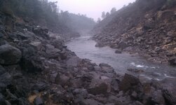
Hiking the South Fork American river

infotraker

Full Member
Dec 20, 2013
193
282
Ca
Detector(s) used
Whites mxt
Primary Interest:
Prospecting
had a cold start to our hike up the river from the Salmon Falls bridge on the north side. Found some nice flakes about a mile up river, a hard hike over lots of large rocks.
Upon returning yo the bridge there were many people digging in the rocks below the parking lot. A ranger showed up and alerted everyone to stop digging, sluicing and using digging implements. It actually is a hands and pan only area but seldom anyone says anything or cites anyone. This might change as there are a lot more people out there now.
 

Upvote 0
I believe at the bridge is Folsom park land and upstream is BLM land.

GM
 

Hike until your exhausted, then go twice as far, then dig until 3 hours before dark. Hope your legs hold up on the walk back. That usually does the trick. IMAG1172.jpg
 

Hike until your exhausted, then go twice as far, then dig until 3 hours before dark. Hope your legs hold up on the walk back. That usually does the trick.<img src="http://www.treasurenet.com/forums/attachment.php?attachmentid=940888"/>

I absolutely Love that!
 

Hike until your exhausted, then go twice as far, then dig until 3 hours before dark. Hope your legs hold up on the walk back. That usually does the trick.View attachment 940888

Aufisher is correct. Nothing like hours of violent leg cramps after prospecting all day. This pic taken at 1st rapid is not even close to where you need to be. If you can do 3-4 hours straight on a stairstepper then this is the hike for you.
 

Hey I know that "trail" great place but man leg cramps is correct!!!!
 

Man I wanna check that area out...


Sent from my iPhone using Tapatalk
 

Man I wanna check that area out...


Sent from my iPhone using Tapatalk
Go for it! It's a great spot to get away from it all and get some color!
 

No sign and not asra. Its the border of Folsom Lake Rec. area that creates the pans only designation. ASRA is not hands and pans only.Where the picutre is taken is just plain blm land
 

Go upstream to Chili bar as much less hastles,less folks,out of recreation area restrictions and less people. At least it used to be as things change fast now in this sic sic sic anti-mining state-John
 

There's only flood gold at the rafter put in at Chili Bar. no real bedrock to work. You have to pay to park. There are new home owners at the private property down stream and they will come out and chase you off and call the sheriff if you try to walk by even in the water. In El Dorado county private property goes to the middle of the water course so you can't argue with them. If you have a kayak ,tube or raft your good to go.But, you better know what your doing cause its a long way to up red shack trail or float to Coloma.I've snuck in and out before and you can hike Texas canyon. Honestly there are no hassles at Salmon Falls unless you try to work from the bridge down as mentioned before.
 

Last edited:
Down river is/was chunky gold. There was a public access trail on the north bank that was a public easement. I'd hit the county and take the time to look as folks always talk bs when it comes to access and try to hastle you. Times they are a changing and NOT for the good either. John
 

That's the side I'm talking about John. There's a few houses with one at the end of the drive way having new owners. They have signs staked all the way out into the water. and a fence going down to the willows. We used to snipe down there even with the old owners we would put on our suits and float down, then be very quiet on the way out. You are correct past there is good gold. There is no easement unfortunately. I wish there was. Its on my wifes commute she passes it twice a day ten minutes from my house I would have her drop me off. I think previous owners were just ok with people going by when it was only occasional. You know how its been the last five years lots of people think theyre gonna strike it rich and try to hit anything that appears open...regardless of ownership. I think they got sick of droves of people trampling through their front yard. Its one of the closest spots from Placerville to hit the river for weekenders who want to party at the river. My wife works for the county so I'm gonna recheck but when I looked it up on the map the property line went to the center of the river and no easement was shown.I'll go to the surveyors office they're starting to get used to me:laughing7:
 

Last edited:
Hike until your exhausted, then go twice as far, then dig until
3 hours before dark. Hope your legs hold up on the walk back. That usually does the trick.
View attachment 940888

Honestly? I wouldn't even attempt it...maybe I'd make it
50 yds before you'd be calling in the medi-vac, and I hate flying!...
rofl.gif~original


My wife works for the county so I'm gonna recheck but when I looked it up on the map the property
line went to the center of the river and no easement was shown.I'll go to the surveyors office they're starting
to get used to me.

Don't know how it is in Calif., but up here people can legally access the beach provided
they travel in on state waters. They can't trespass on my land to reach the river, but
they can come in by boat and beach there. At the moment one of the local tribes has got
a gillnet anchored to my beach, and there's not a damn thing I can do about it..
bur2.gif~original


Is there a place where the river goes under a road, and you can access it
via the public easement?
 

Last edited:
Yea, Dizzy its a county law not state. Creeks cross so much private property here. The County states that you own to the middle of the river. You can float by but can't stop. Believe me man I wish it was different as it cuts off access to some awesome places unless you have something to float in.
 

Hill net in your back yard. Time to bust out the smoker.
 

Top Member Reactions

Users who are viewing this thread

Latest Discussions

Back
Top