✅ SOLVED Gravity Control Mark

Viddy

Sr. Member
Aug 16, 2011
447
220
Harrisburg, PA
Detector(s) used
Xterra 705, F2, Etrac, T2, V3i, AT Pro, CTX3030, Equinox 800, Vanquish 540, Go-Find 66, F5, Q60, Apex
Primary Interest:
Metal Detecting
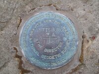
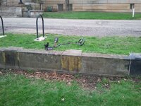
I happened upon a wall while detecting and noticed this disc implanted/cemented in the top of the wall. Anyone have no idea what the heck it is?

it reads:

For Information Or To Report Damage Write Washington DC
Gravity Control Mark
National Geodetic Society
The Director
Pittsburgh CA 1989

Strange stuff you find sometimes, huh?

I was hoping to get the V3i levitating in the picture, but it never happened. Oh well.
 

Attachments

  • 2013-04-16 gravity 2.jpg
    2013-04-16 gravity 2.jpg
    247.2 KB · Views: 216
  • 2013-04-16 gravity 1.jpg
    2013-04-16 gravity 1.jpg
    313.5 KB · Views: 158
the differance is a regular soil placed survey marker can only be certified to a certain accuracy.But when a location that is much more stable vertically,a wall,outcropping etc happens to be where marker is to be set....it can be classified as a higher standard of accuracy.In disputes...these markers are preffered.hope it helps
 

Upvote 0
Is the marker in Pittsburg, California, as it indicates by the stamping? :icon_scratch:
 

Upvote 0
Hello, I am with the NOAA-National Geodetic Survey and I set this survey marker. Gravity Control Markers do not allow one to 'control' gravity. rather it is a place were the acceleration of gravity has been measured precisely for geodetic and geophysical work. From here other gravity survey surveys can be referenced and control (i.e. a gravity value) can be provided on other paperwork or a website. The acceleration of gravity here is 9.80 080 796 (+/- 3 in last digit) meters/second/second. This is at the Allegheny Observatory in Pittsburgh, PA. The CA does not refer to California, nor is it a mistyping of PA. The CA is a code used by gravity folks to mean the excenter to first absolute gravimeter site in the city, i.e. excenter to PITTSBURGH AA located inside the observatory. The survey mark could also get elevation and/or latitude/longitude control, say from a GPS survey. If you would like to visit other gravity stations, search Regional Geospatial Service Center Dan Winester
 

Upvote 0
Wow
Thank you for the information.
WAY!! over my head, but neat info just the same.
Thanks again Dan and welcome to Treasurenet
 

Upvote 0
Hey deadfisherman

I retired from the Survey/engineering field 3 years ago. At the time we were waiting on a new geoid model for Alabama. Has NGS released a new one yet, now that I don't need one. LOL

Bamadad
 

Upvote 0
Hello, I am with the NOAA-National Geodetic Survey and I set this survey marker. Gravity Control Markers do not allow one to 'control' gravity. rather it is a place were the acceleration of gravity has been measured precisely for geodetic and geophysical work. From here other gravity survey surveys can be referenced and control (i.e. a gravity value) can be provided on other paperwork or a website. The acceleration of gravity here is 9.80 080 796 (+/- 3 in last digit) meters/second/second. This is at the Allegheny Observatory in Pittsburgh, PA. The CA does not refer to California, nor is it a mistyping of PA. The CA is a code used by gravity folks to mean the excenter to first absolute gravimeter site in the city, i.e. excenter to PITTSBURGH AA located inside the observatory. The survey mark could also get elevation and/or latitude/longitude control, say from a GPS survey. If you would like to visit other gravity stations, search Regional Geospatial Service Center Dan Winester

Wow! You just never know when a out of the blue expert shows up here! Thanks for the read - :)
 

Upvote 0
Hey deadfisherman

I retired from the Survey/engineering field 3 years ago. At the time we were waiting on a new geoid model for Alabama. Has NGS released a new one yet, now that I don't need one. LOL

Bamadad

Well, NGS has a series of hybrid and experimental geoids. see National Geodetic Survey - Home / tools /GEOID12B. We are not doing individual states (except AK, HI and territories). In 2022 there will be a new reference frame (aka datums) combining horizontal and vertical (& gravity and DOV) with a time dependent component. The geoid will be gravity determined, not a hybrid of leveling, gravity, tide gauges and GPS; thus our GRAV-D program.
 

Upvote 0

Top Member Reactions

Users who are viewing this thread

Latest Discussions

Back
Top