Gossan question

UncleMatt

Bronze Member
Jul 14, 2012
2,389
2,531
Albuqerque, NM / Durango, CO
Detector(s) used
Garrett Infinium & Gold Bug II, Bazooka Super Prospector Sluice
Primary Interest:
All Treasure Hunting
Hi All,
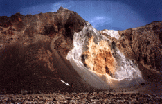
Take a look at the attached photo. I am curious what you all think about the gossans in the photo, and whether or not they are deserving of prospecting. I do not have much experience with exploiting gossans, and look forward to hearing your opinions. This is in a very remote area, and is very hard to get to, so I was thinking about about perhaps panning the drainage plume from this area to see if it showed any colors.
Gossans.JPG
 

Hello
The red one assumes is iron and gold often rides a iron horse as they say. What is the light gray color?
The soil or rock also appears to be small loose material that may be hard to dig out without a land slide of some type. Be careful.
 

Yep I believe that panning the drainage would be a smart 1st step ! what about state geological reports of that area. Look for them in the states Natural Resource Department in the state maps /reports . they are usually free or VERY LITTLE COST ! After all , you've already paid for them to do it for you! Good Luck!
 

Hello
Try panning in the mineral zones above and below the red iron as well for values. You will have to hike up to that area to find out what this zone rock is.
May not hurt to try some gold metal detectors as well. Can not tell what the light gray material is.
 

From the looks of it, the appears to be an old volcanic cone. I would be really careful on this one. Lots of opportunity for a landslide. Pan the iron streaks and above and below them if you can do so safely. Remember no amount of gold is worth dying for.
 

Cinders? lol, what do you mean?

I saw these gossans across the valley from a trail I was on last week. There are no trails to these iron rust sites, so as I said I will try to sample the material in the chute below.
 

The type of structure you show in your picture UncleMatt is a Debris Avalanche. The "gossans" are actually a typical feature of Debris Avalanches and are technically termed "Hummocks". Hummocks have no relationship to gossans.

Gossans are not associated with Debris Avalanches, in fact the most common association with a Debris Avalanche are volcanoes. The "rust" and white colors you are seeing are also very common features of volcanic Debris Avalanches.

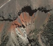
Here is a recent Debris Avalanche on Mount Saint Helens - a rather well known Volcano.
aval2.gif
Notice how the hummocks are very much like your presumed gossans? See how the coloration and slump pattern is virtually identical to your photo?

Taking the visual aspects that clearly show a Debris Avalanche, knowing that Albuquerque and Durango are both on the volcanic cordilla and having seen many such structures in that same area of the country the most logical conclusion is a Volcanic Debris Avalanche. Seeing the resistive basalt cap and the steepness of the collapsed slope below indicates a loose poorly consolidated lightweight fill material. Volcano + Debris Avalanche + hummocks + loose poorly consolidated lightweight fill material = most likely cinders. Cinders never equals gold or gossans.

Do I know that those are cinders in fact? Of course not, I haven't been to the location and neither have you. I do however have some very good experience and a lot of geology to back up my assumption.

I would suggest rather than climbing up there and sampling you simply study the local geology. I think you will find that the slope you are interested in is indeed volcanic debris. Another possibility would be to look for magnetic anomaly studies of the area, with a closer look I think you might find you don't need to move dirt to know what's there.

Heavy Pans
 

Last edited:
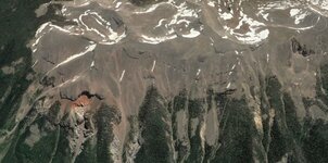
Here is another photo of the area so you can see the surrounding terrain. These rust spots are the only areas showing signs of mineralization on a very high ridge. Which is why they drew my attention and made me think they might be worthy of further investigation. This is a geographically diverse area, with volcanic tuft, sedimentary strata, and a variety of granites.

Gossans2.JPG
 

Correct me if I'm wrong but Gossans occur when a sulphide deposit is severely oxidized via acidic waters leeching minerals and transporting them down to near the current water table where they are redeposited creating an enriched zone deep under the now barren (economically) upper structure of the deposit. I remember reading about these types of deposits within (under?) the arkose sandstones of Colorado's high country (Gilpin district I think?)... it's been a while. Anyone chime in? That said if you are looking at a gossan the highest concentration should be in a relatively thin layer at the contact zone between formations.
 

Last edited:
Correct me if I'm wrong but Gossans occur when a sulphide deposit is severely oxidized via acidic waters leeching minerals and transporting them down to near the current water table where they are redeposited creating an enriched zone deep under the now barren (economically) upper structure of the deposit. I remember reading about these types of deposits within (under?) the arkose sandstones of Colorado's high country (Gilpin district I think?)... it's been a while. Anyone chime in? That said if you are looking at a gossan the highest concentration should be in a relatively thin layer at the contact zone between formations.

What you're describing is known as supergene enrichment. The barren area can occur between enriched layers depending on the process of the chemistry. You also don't need to intercept a water table, only an area of alkaline rocks where the water becomes reduced thereby depositing the minerals in that layer. Opal and turquoise are both formed like this.

A gossan is any weathered oxidized mineralization zone. The age of the gossan, paleoclimate, sub-soil geochemistry and a host of other factors determine where the enrichment zone is, and if there is any barren zone at all. If a gossan is sitting on a granite cap, not much is going to happen most of the time. That again all depends on the geology under the cap.
Thank you for the details. Not everyone is going to look at geology however this can really help in finding where the good stuff is. No word yet on any panning down from this.
 

And there won't be until next summer! lol

This is not in an area that is easily accessible. Many miles from the nearest road, and some of the roughest terrain imaginable. I was up there early last month, and the last night we were up there we had ice covering the tent come morning. Now snow is already falling up there. So it will be next year before anything happens on this.
The good news is that no one will be panning down below before next spring or summer. There will not be any other equipment like a sluice box as well. Keep us posted.
 

I might take my Bazooka sluice when I go back, you never know...
 

I might take my Bazooka sluice when I go back, you never know...
Yes if there is enough water the Bazooka or any sluice will not only process more material but not chill the hands like hand panning can. There will not be any values in the cinnder type of rock however what is just below that is the question. You may be one of the first people to check this out. Be safe above every thing else. Would like to see someone make a battery powered shaker that one can put a gold pan on for the hard to hike and low water areas.
 

Yes, I am aware. It appears that a layer of volcanic tuft sits on the layer with the rusting material in it. This is pretty unique for the area, with only a couple such spots showing up, which is why it caught my eye.
 

Top Member Reactions

Users who are viewing this thread

Back
Top