BuffaloBob
Bronze Member
- Jan 6, 2005
- 1,367
- 263
- Detector(s) used
- Minelab X-Terra 705 Gold Coil
deteknixXpointer Probe
Minelab Ex-Terra 70
White's Classic II
2014-2015 Colorado Gold Camp Prospector
- Primary Interest:
- Metal Detecting
Google Earth is my best friend. Love looking at old maps and stories about communities that once thrived and are now lost.
By Lost I mean you can't find in your car. Nothing visible from the road even across flat land. You know something is out there but all landmarks, structures etc are gone. Plowed under, destroyed or built on. Then I discovered Google Earth.
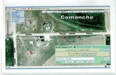
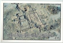
For example we were looking for the actual site of a stage stop in COMANCHE COLORADO. Here's what we found from the air..

Using mapping software ACME MAPPER 2.0, foundations are clearly visible. Their software allows Topo and Terrain overlays.
Topo shows structures not evident on Google till you look closely.
Mark every possible habitation site.
Take a screen shot which includes GPS data.
Write the name of the place in terms you can research later: History of the area, structures, families, etc. That is so interesting to me.
One townsite is known in local lore only.
Original town flooded out.
Moved to higher ground
Tornado struck so moved again
Fire this time. Still a garage standing but the original sites are unknown.
Looking at historical records, old photographs, my friend Doug brought the local county history book along.
He knew which Creek flooded so the area was roughly known. And plowed and planted fields. No signs of anything.
UNTIL Doug said "isn't that the wooden Windmill in the picture"? Wow.. YES IT WAS.
That was the original town site. Couldn't get the van through the wash. Bridges long lost. Four wheeler could make it OR long hike for some tired old guys. Instead glassed the area with Binoculars. And I shot a picture.
Now having a statrting spot for townsite #1, and #3 we knew the #2 location was somewhere nearby.
Google Earth showed that site planted and no access road other than farm access. Probably nothing there but WE DID IT! Found the bugger, lost for generations. And have the GPS data and pictures. To return if we want to.
That's my story and I'm stickin to it!
BB
By Lost I mean you can't find in your car. Nothing visible from the road even across flat land. You know something is out there but all landmarks, structures etc are gone. Plowed under, destroyed or built on. Then I discovered Google Earth.
For example we were looking for the actual site of a stage stop in COMANCHE COLORADO. Here's what we found from the air..

Using mapping software ACME MAPPER 2.0, foundations are clearly visible. Their software allows Topo and Terrain overlays.
Topo shows structures not evident on Google till you look closely.
Mark every possible habitation site.
Take a screen shot which includes GPS data.
Write the name of the place in terms you can research later: History of the area, structures, families, etc. That is so interesting to me.
One townsite is known in local lore only.
Original town flooded out.
Moved to higher ground
Tornado struck so moved again
Fire this time. Still a garage standing but the original sites are unknown.
Looking at historical records, old photographs, my friend Doug brought the local county history book along.
He knew which Creek flooded so the area was roughly known. And plowed and planted fields. No signs of anything.
UNTIL Doug said "isn't that the wooden Windmill in the picture"? Wow.. YES IT WAS.
That was the original town site. Couldn't get the van through the wash. Bridges long lost. Four wheeler could make it OR long hike for some tired old guys. Instead glassed the area with Binoculars. And I shot a picture.
Now having a statrting spot for townsite #1, and #3 we knew the #2 location was somewhere nearby.
Google Earth showed that site planted and no access road other than farm access. Probably nothing there but WE DID IT! Found the bugger, lost for generations. And have the GPS data and pictures. To return if we want to.
That's my story and I'm stickin to it!
BB


