Florida Beach Renourishment

ColonelDan

Bronze Member
Jan 19, 2014
1,007
2,183
Central Florida
🥇 Banner finds
1
🏆 Honorable Mentions:
1
Detector(s) used
Deus II
Primary Interest:
Beach & Shallow Water Hunting
Info for those who hunt along Florida’s A1A.

My hunting buddy and I drove to Melbourne Beach this morning only to find the aftermath of the latest massive renourishment program. Not a target to by found! We drove south all the way to Ambersands beach entrance stopping along the way to check out other beaches along that road and what we saw was truck after truck along A1A waiting their turn to dump more sand on our beaches.

Needless to say all we got this day was a lot of exercise. In the end, we decided to hold off detecting there until either the weather warms up and depositors return en masse or storms reverse the effects of the renourishment effort.
 

Upvote 0
Next big storm,or two will remove it all and the cycle begins a new :)
 

That brings up this question....All this sand goes through some kind of sifter ,right ? Where is that sifter at the end of the dredge tube(on land) ? Or on the dredge at sea ?
 

That brings up this question....All this sand goes through some kind of sifter ,right ? Where is that sifter at the end of the dredge tube(on land) ? Or on the dredge at sea ?

Does anyone know ?
>>>
 

Last edited:
The sand is brought in from sand pits inland... not beach sand... it is full of can slaw and 99.9% of the time, nothing of a historical nature is in it... just under it... WAY under it!!
 

Ambersand, Treasure Shores and Golden Sands to Wabasso are getting sand through April. November Wabasso and south. The beach communities discovered if they all put sand on the beach, if it erodes it goes south and adds to beaches to the South.
 

Ambersand, Treasure Shores and Golden Sands to Wabasso are getting sand through April. November Wabasso and south. The beach communities discovered if they all put sand on the beach, if it erodes it goes south and adds to beaches to the South.

Hmmm... well this would defy the "law of nature" for area.... so again "they" are wrong.

Flow is north... and deposited on cape.
 

Prob both ways at diff times, but looking at the seb and ft pierce inlets, over time the south side is eroded more while the north sides build up. Plus depends on the wind direction, if you stand on the beach with a moderate to strong northerly wind you can watch sand move south. Offshore, the Florida current and Gulf Stream flow north but move away from shore around Palm Beach.
 

Prob both ways at diff times, but looking at the seb and ft pierce inlets, over time the south side is eroded more while the north sides build up. Plus depends on the wind direction, if you stand on the beach with a moderate to strong northerly wind you can watch sand move south. Offshore, the Florida current and Gulf Stream flow north but move away from shore around Palm Beach.

No my son... One way... Always.
 

Its called the "Gulf Stream"... this is what the Spanish "rode" north... the same Spanish that your deviders came from :)

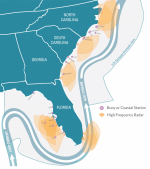
secoora-stylized-map-large-911x1024.png
 

We both agree ‘they’ are wrong again about sand renourisment at least.

I am referring to current at the beach, in my area the northward flowing Gulf stream is 12-14 miles offshore as shown in your diagram North of Palm Beach.

North to south current is under “Longshore transport” here: https://fcit.usf.edu/florida/teacher/science/mod2/changing.coastlines.html

But a more interesting article is here: under the yellow diagram, https://treasurebeachesreport.blogspot.com/2015/07/7315-report-how-noreasters-produce.html
 

Test for yourself... get a BIG cheap beachball... and let it loose in the surf :)

It will go south AND OUT... then North. :)

What is sucked outward is then carried northward.

Which is why they have never found the remaining ships... they are WAY north... ALONG WITH all that sand we are talking about. :)
 

On our coast, there are outcroppings, underwater canyons, and man-made breakwaters and jettys that can effect the overall southward current causing eddy currents that go the opposite way of the main current. You add storms to that mix and sand can go in any direction. Overall, it goes south here, but, in the short term it can go anywhere. We just like it when it goes, regardless of direction! :laughing7:
 

Test for yourself... get a BIG cheap beachball... and let it loose in the surf :)

It will go south AND OUT... then North. :)

What is sucked outward is then carried northward.

Which is why they have never found the remaining ships... they are WAY north... ALONG WITH all that sand we are talking about. :)

Makes sense, thanks
 

Yes hearing the good news on possible treasure from the Spanish galleons coming my way with the Gulf Stream..also by me in the Hudson River during the Rev.war a iron chain was placed in the water across it to also stop the British ships from advancing as they burned part of Kingston down when it was NYs Capitol..Here Now we can also search for possible wrecks up here too
 

Yes hearing the good news on possible treasure from the Spanish galleons coming my way with the Gulf Stream..also by me in the Hudson River during the Rev.war a iron chain was placed in the water across it to also stop the British ships from advancing as they burned part of Kingston down when it was NYs Capitol..Here Now we can also search for possible wrecks up here too

Possible,but that island (the chain was connected to) on the East side of the Hudson is LOADED w/snakes & is now Fed. property .
 

Yes I think it’s bannermans Isl..I’m not sure of the spelling Also there was ammunition’s stored there also
on the other hand many years ago for a summer job I worked clearing woods to become a park near there and found a nice gold ring and finding out now that Thomas Jefferson lived there
 

Also the Hudson River has tidal waters so it’s possible that treasures can be located miles away
 

Top Member Reactions

Users who are viewing this thread

Back
Top