Finding old Indian Camp sites.

Gare

Gold Member
Dec 30, 2012
8,364
15,797
Canton Ohio Area
🏆 Honorable Mentions:
2
Detector(s) used
Presently using Deus 2's & have Minelabs, Nokta's Tesoro's DEus's Have them all . Have WAY to many need to get rid of some
Primary Interest:
All Treasure Hunting
How do you flint hunters determine where to look for flints and such ? Lets say there was a major stream near. How would you find a camp site ? How far away from the stream would they camp ? Probably on the high spots to begin with . How far away from the stream would they camp (Main camps also)
 

I mostly hunt fields around here but do find occasional camp sites in the fields. Very few are on what I call high ground but are above areas where water might collect and in what I think would have been places that could have been somewhat sheltered from the wind. Some are close to current water sources and some might be 1/2 mile from the nearest stream or old water source. In the last 10,000 years springs and seeps have come and gone so who knows what water sources were there before the land had been changed by tilling, tiling, and clearing off the watersheds. Around here I do seem to find more camp sites along the bluffs above creeks and rivers. If I were looking for sites on virgin ground, I think I would look in places above but close to a water source, somewhat sheltered, and a place where I might want to set up my permanent or temporary camp.
 

I mostly hunt fields around here but do find occasional camp sites in the fields. Very few are on what I call high ground but are above areas where water might collect and in what I think would have been places that could have been somewhat sheltered from the wind. Some are close to current water sources and some might be 1/2 mile from the nearest stream or old water source. In the last 10,000 years springs and seeps have come and gone so who knows what water sources were there before the land had been changed by tilling, tiling, and clearing off the watersheds. Around here I do seem to find more camp sites along the bluffs above creeks and rivers. If I were looking for sites on virgin ground, I think I would look in places above but close to a water source, somewhat sheltered, and a place where I might want to set up my permanent or temporary camp.
FlintHunter THANK you SO VERY VERY MUCH for your GREAT INFO 111
 

Toddspoint thank you very much i wouid think the same thing. How far away do you think they might camp from where the two springs meet ? (distance feet)?
 

I would think Google earth would be a HUGE help in locating some of these camp sites ?
 

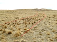
I think it all depends on the terrain and resources. A fishing society would be near the source of that bounty. An agricultural society around good land to plant crops. The hunter gatherers set up temporary camp and followed the game and used the geographic features of rivers and steam as their guide to the places to go and set up camp like here on the high plains where I live. Just outside of town I found such a place. The hill top is where they camped. I also found evidence close to the creek where they must have did things like flint napping as the ant mounds have small chips of the chalcedony and jasper used to fashion blade tools. Very old pieces of bone could be found from game processing I believe and also what I believe was an ancient road to the top of the hill where they could survey the land around them from their hill-top headquarters for the time they'd be there for the season. I believe other artifact collectors have picked over the area from the evidence they've left behind, but I still find evidence of the existence of the ancient ones at a place they may have called "Where the two small steams meet"
 

Attachments

  • IMG_20151124_163230829.jpg
    IMG_20151124_163230829.jpg
    605.5 KB · Views: 220
  • Screenshot_20220214-090705_Maps.jpg
    Screenshot_20220214-090705_Maps.jpg
    73.7 KB · Views: 388
  • IMG_20170906_121149.jpg
    IMG_20170906_121149.jpg
    1 MB · Views: 227
  • land mark old trail.jpg
    land mark old trail.jpg
    4 MB · Views: 389
I think it all depends on the terrain and resources. A fishing society would be near the source of that bounty. An agricultural society around good land to plant crops. The hunter gatherers set up temporary camp and followed the game and used the geographic features of rivers and steam as their guide to the places to go and set up camp like here on the high plains where I live. Just outside of town I found such a place. The hill top is where they camped. I also found evidence close to the creek where they must have did things like flint napping as the ant mounds have small chips of the chalcedony and jasper used to fashion blade tools. Very old pieces of bone could be found from game processing I believe and also what I believe was an ancient road to the top of the hill where they could survey the land around them from their hill-top headquarters for the time they'd be there for the season. I believe other artifact collectors have picked over the area from the evidence they've left behind, but I still find evidence of the existence of the ancient ones at a place they may have called "Where the two small steams meet"
Tamrock thank you so very much for your reply :) what you all are saying makes sense :)
Thanks
 

I do pretty good where two creeks come together.
Or where 3 streams meet as the white man labeled many a place of 3 intersecting streams Turkey Foot and I wonder if it was the white man that came up with that description or they just went with what the native peoples in their language called such a place.
 

Gare,we don,t have much exposed rock around here or gravel deposits.A childhood friend had a nice collection of arrowheads he found in a small creek that had exposed gravel,right next to his house.He,d just walk that creek and find them with his eyeballs. This is Delta country,lots of deep soil,so I,m guessing this was the only source of rock for points in a large area.I,m no geologist so I don,t know why this little creek in the middle of the Delta has exposed gravel deposits.We got Mounds,but of course they,re off limits to hunting and on private property.There,s one about 6 miles from the creek I speak of. I don,t know if this helps,just thought I,d throw it out there.Oh,and the Mound I speak of is right on the banks of a large bayou.
 

If you are looking on Google earth another thing besides water sources could be areas of rock that could be used for grinding. My Mother took all of us kids to an old summering area our tribe used and it was exactly what I am describing next to a water source and grinding holes all over the granite outcropping and we pulled hundreds of pounds of pottery from there and arrowheads. My Mom used to make resin and pottery tables from the pottery. Last time I went there I found a lot of broken bottles as people don't realize it is a Indian summer camp and it sits right next to a road. but there is still pottery there if your eyes know what they are seeing, but the last arrowhead I found there was as a teenager and I am 40 years past being a teenager now.
 

I always look for three things. Proximity to a water source. Close but not too close. High enough to keep you away from the bugs. Keep in mind that the water source location has most likely changed so look for Old Creek channels not just existing creeks. Locations for two streams meet are always a bonus. Some type of windscreen whether it be trees or Bluffs. And a high spot nearby where the Braves could set and watch over the camp and make sure they had plenty of view for any approaching trouble. The high areas are places where I often find points because that is where the members of the tribe that were on watch would set and knap Flint while they are watching for trouble trouble.
 

Top Member Reactions

Users who are viewing this thread

Back
Top