HollandsBrook
Full Member
- Joined
- Jun 27, 2008
- Messages
- 103
- Reaction score
- 6
- Golden Thread
- 0
- Location
- Scotch Plains, NJ
- Detector(s) used
- CTX 3030
- Primary Interest:
- All Treasure Hunting
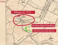
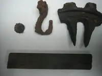
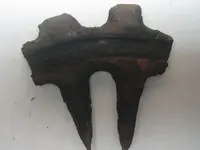
Hello all. I live near an old village that was est. in 1711 in central jersey. as a kid, i spent countless hours in the creek/woods near this village fishing, building forts, etc. One day i stumbled upon an old well about 10 yards away from the woods-line, near an old road leading up to this village. the well is halfway between the road and the creek and was always mysterious to me as there are no old houses in the immediate area. I decided to detect this area a few months ago and dug a Rev. War period french colonial navy button a few feet from the well. (ive posted this find in this forum in the past). i also dug an old horseshoes, oyster shells, nails, and odd metal pieces that i concluded to be wagon parts. a few members of this forum and others suggested there might have been some sort of dwelling near this well as part of the village down the road. perhaps a temporary, one room dwelling for those building a house down the road. after 2 months of looking through old maps of the area for a marking in this spot, i've finally found something very interesting. i cropped the map and made some markings of my own in photoshop for easier understanding. a few questions of the top of my head based on this illustration are:
1. would a cartographer in 1903 make a marking as pointed out in this picture for anything other than a house or building? i.e, shed, barn, etc.
2. the marking here is on the east side of the creek (much lower than the west side where the well is). Would it make sense to build on the low side of a creek for fear of flooding?
3. why would a house and the house's well be on opposite sides of a creek? especially with the well on high side.
I dont believe that this would have been a temporary house for the village down the road because it is depicted on a map in 1903. By then the villagers would have torn down this temporary dwelling and used the materials for the new house. I am extremely familiar with this wooded area in question, and have never come across any cellar holes. if you notice there is another small dot across from the one in question here that is also not in existence today.
any help, answers to my questions, or thoughts would be much appreciated. thanks for reading!


