Navigation
Install the app
How to install the app on iOS
Follow along with the video below to see how to install our site as a web app on your home screen.
Note: This feature may not be available in some browsers.
More options
You are using an out of date browser. It may not display this or other websites correctly.
You should upgrade or use an alternative browser.
You should upgrade or use an alternative browser.
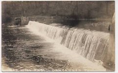
Duncannon Dam
- Thread starter generik
- Start date
deepseeker41
Newbie
- Feb 22, 2007
- 2
- 0
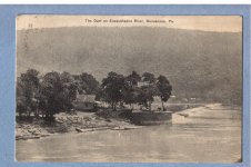
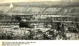
This is the area locally known as "the point".The vantage point of the camera is looking down the Juniata river towards the Susquehanna.The dam is for the Clark's Ferry.It looks like (the photo) predates the toll bridge that replaced it.The toll bridge was replaced by a 4 lane highway bridge.
This is an interesting post card and would love to know the date it was printed.Several of the trees are still there and alive today although they are of course much larger.The building in the photo is long gone.
I also own most of this property.The site of the building looks to be on my part of the property.it could be triangulated using the trees and abutment for referance.There were more than just that one structure on the site as well.This was also a likely camping spot for indians and settlers . It is the very tip of what was once called Duncan island.
Top Member Reactions
-
 3342
3342 -
 1899
1899 -
 1872
1872 -
 1174
1174 -
 1093
1093 -
 874
874 -
 830
830 -
 829
829 -
 827
827 -
 784
784 -
 778
778 -
 535
535 -
 504
504 -
 482
482 -
 430
430 -
E
415
-
 415
415 -
 397
397 -
 396
396 -
 391
391
Users who are viewing this thread
Total: 2 (members: 0, guests: 2)


