Nu2Poo
Jr. Member
- Joined
- Oct 4, 2007
- Messages
- 52
- Reaction score
- 31
- Golden Thread
- 0
- Location
- Cincinnati
- Detector(s) used
- Whites Xlt w/ Bullseye pinpointer
- #1
Thread Owner
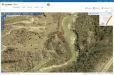
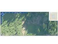
Here's a neat way to check remote areas for potential detecting sites. A friend of mine stumbled upon this while viewing aerial images. Rather than google earth aerial imagery, this is called birds eye and things tend to show up better I think. If I had been looking at aerial images I never would have seen this house mostly due to what time of year it was taken and angle of image.
go to maps.live.com
find your area and click on birds eye at the top of page. This may or may not be available in your are though. Good Luck!
go to maps.live.com
find your area and click on birds eye at the top of page. This may or may not be available in your are though. Good Luck!