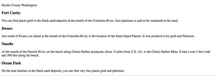
columbia river

I know this has been here for a while but since I just found it thought I'd say
thanks for posting these, been looking for something like this.....:thumbsup:
 

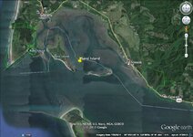
There's 3 ways to the islands, and all call for a seaworthy boat. A jet motor is best because of the sand flats...and a very waterproof tent for a few days stay to really enjoy the peace and solitude and......sluicing.
I always wanted to do that except it's Oregon and the laws suck......yuck!
 

There's 3 ways to the islands, and all call for a seaworthy boat. A jet motor is best because of the sand flats...and a very waterproof tent for a few days stay to really enjoy the peace and solitude and......sluicing.
I always wanted to do that except it's Oregon and the laws suck......yuck!

I agree.... BS rules and regs.
As to a proper craft... I'm thinking....HOVERCRAFT.... yee haw.
The islands aren't in park lands that I know of (could be wrong, wouldn't be the first) So I'm not sure the no motor thing would apply.
I have NO idea what getting a river permit would entail though.
Also it appears little sand island east end is in Washington....
And what about Ruby island?... to the west of big sand island, it's in WA.


Sand Island.jpg
 

Last edited:
Last edited:
I was looking at the Google Earth image you posted and your question regarding park lands etc., I think you will be happy with Google Earth Pro. It's free which is great (I thought it would be a arm and both my legs... Lol) the license key they have posted on the website to use to download the PRO version is "GEPFREE" I used it tonight to update my own maps and I was for once shocked there was no catch. So now all future imagery updates will happen since I downloaded this version and removed the old (per the instructions) The Layers that are available are exactly what you are looking for I think. I am a map junkie and I couldn't choose the Layers fast enough. It did show Port Canby State Park where you had mentioned. Parks/Rec section(s), US Fish/Wildlife, Forest section, boundaries and every save the earth save you save me protected areas are, but in the end you hopefully know where your feet can take you by water or land. I wouldn't have found the free Pro license opportunity if I had not researched your map, so Thanks! Hope this info helps.
 

I was looking at the Google Earth image you posted and your question regarding park lands etc., I think you will be happy with Google Earth Pro. It's free which is great (I thought it would be a arm and both my legs... Lol) the license key they have posted on the website to use to download the PRO version is "GEPFREE" I used it tonight to update my own maps and I was for once shocked there was no catch. So now all future imagery updates will happen since I downloaded this version and removed the old (per the instructions) The Layers that are available are exactly what you are looking for I think. I am a map junkie and I couldn't choose the Layers fast enough. It did show Port Canby State Park where you had mentioned. Parks/Rec section(s), US Fish/Wildlife, Forest section, boundaries and every save the earth save you save me protected areas are, but in the end you hopefully know where your feet can take you by water or land. I wouldn't have found the free Pro license opportunity if I had not researched your map, so Thanks! Hope this info helps.

Well.... lets see some of these images..
 

Top Member Reactions

Users who are viewing this thread

Latest Discussions

Back
Top