Civil war artifacts - where?

BrettCo124

Hero Member
Apr 29, 2009
901
939
Outside of Philadelphia, PA
Detector(s) used
Minelab Safari, Tesoro Sand Shark, Bazooka Gold Trap Mini, Gold Rush Nugget Bucket, Garrett Supersluice Gold Pans
Primary Interest:
All Treasure Hunting
Hi all,

Not looking for exact locations, just advice. I’ve never found civil war artifacts before. I live in Pennsylvania, right by Philadelphia. Just curious, are there artifacts basically everywhere? Or do I need to find a location where a battle occurred, or something along those lines, in order to find something?

Thanks all.

BrettCo
 

I don't have experience finding Civil War relics but I have plenty in finding WWII items. Half the battle is research in the form of books, magazines, old maps, word of mouth and scouring the internet can give you a wealth of information. Obviously there is not any detecting in federal designated war memorial areas so think outside the box. Troops had to bed down in various places and there could have been small skirmishes in many different places. See if you can find any routes which the troops may have taken between cities/towns.

Hope this helps. Good luck.
 

Thanks so much! I’m going to try doing some further research.
 

My research is not really coming up with much unfortunately. I just don’t know how to go about this. I live near a ton of nice beaches, including Delaware river, New Jersey beaches, and Chesapeake bay in Maryland. Is that where you’d look?

Thanks so much all.
 

Thank you so much to both of you. It’s always hard asking those questions without sounding like I’m trying to just cheat and get someone to give me locations. I’ve never targeted war relics before, which I’m so excited to start trying to do. I appreciate the advice and hopefully I can find my first relic!
 

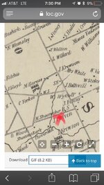
I have another question for you all. Would you be able to help me read this map from early 1800s? According to what you see at the red X I placed on this map, could this be a good area to detect? Even if not for civil war relics?

More importantly, what does the “J Craven” mean? Sorry, I never read maps like this before! It will be helpful for me to understand them better though. ImageUploadedByTreasureNet.com1508629030.275759.jpg
 

Would really love to know the answer to the above question. One thing I’ll need to start learning is how to read maps from back in the day.

Curious on what the names represent. I see the creek, and I’m able to follow that portion of the map easily but what are the black dots and black x’s? For example, at the creeks Y, there is an x that says “clover mill” and a dot to the left of it that says “G Wood”. This map does not have a legend. What does it mean? Is this what most maps look like from back in the day?

Would love to learn more on reading maps and finding maps online to locations I could potentially hunt at. Is there a system everyone uses to see if an area was once homes or something interesting to prospect?
 

I would say that was the residence of someone named J. Craven. Civil War artifacts could be found anywhere, but not likely. I have found a couple buttons at home sites of Civil War veterans. Best bet would be to locate training camp sites.
 

my CW experience came from an invite from another member
Indiana has no CW history to speak of
the Tnet member has access to a farm a few miles from gburg, probably a campsite or lookout post
found cool stuff for my collection
 

Those dots and names represent where houses of people were in the past. Finding a CW camp would be the best thing, if you can. Here's a couple true stories for you. My friends bought a farm PA, no history of the place as such, but I was given permission to search the place. Up popped a few silver coins and some CW artifacts. Looking back at the history, a whole regiment of Federal troops were camped about 4 miles away as the crow flies. Must have a been a lookout post of something. Last fall, was at another random farm that goes back into the 17th century. No real history of CW there either. Looking at the topography I guessed there would be a house on a certain knoll. My buddy and I went over there and I dug four CW officers' buttons from that knoll top and the bases of three fired Henry cartridges. Who would have thought? And there is a park nearby. Found a Confederate button there and a couple minie balls! Boy, I was shocked. And to add embarrassment to the mix, my buddy wanted to dig my front lawn, now how boring is that? I had detected it years ago, just found junk and clad. I nearly fell over when I dug a CW Kepi hat #1 from the CW. He found a Confederate button, TEN FEET FROM MY FRONT DOOR. Legend has it troops were in the immediate area protecting the next door neighbor's grist mill. I guess the legends were right. Point being, when I tell people how it really is metal detecting, the good stuff is everywhere and it is nowhere. Unless you want to join one of the organized digs in Virginia, best bet is to find a house built before 1830, especially once that is long gone and detect there. And prepare to spend a lot of time out digging. You won't find stuff if you don't invest the time.
 

A good place to start researching is a group of Books called "The Official Records of the War of the Rebellion" Available in most large Libraries. A lot of Northern Armies camped and trained in the local area before moving south. The Official Records also has a supplement that gives a history of all the States Regiments. After finding out what Regiments might have trained in the area find out if any Diaries are available. Most Large Universities has Civil War Manuscript collections. A lot are available online. The black dots on the Maps are House's or Buildngs. The Names are the Landowners. A good source of old Maps is the Bureau of Land Management which is available online.
 

Last edited:
I use Historic aerials a LOT. You can overlay new/old maps to get an idea of where to search. I always look for old roads near creeks or bodies of water because that is where they would typically camp. Horses needed water. I have found bullets and artifacts in locations not noted in any books or maps. Not every little skirmish was documented. And certainly not every campsite. Sometimes you just have to do as much research as possible then make an educated guess as to where to search. There are also several books that tell you how to locate campsites and the reasons they chose certain locations. Once i find a promising site on Historic Aerials i go to Google Earth to see how it looks today then i enter the exact coordinates into my gps so i can find it when i get there. Of course i do live in Virginia so that does help a lot with the odds of stumbling onto an unknown site.
 

I use Historic aerials a LOT. You can overlay new/old maps to get an idea of where to search. I always look for old roads near creeks or bodies of water because that is where they would typically camp. Horses needed water. I have found bullets and artifacts in locations not noted in any books or maps. Not every little skirmish was documented. And certainly not every campsite. Sometimes you just have to do as much research as possible then make an educated guess as to where to search. There are also several books that tell you how to locate campsites and the reasons they chose certain locations. Once i find a promising site on Historic Aerials i go to Google Earth to see how it looks today then i enter the exact coordinates into my gps so i can find it when i get there. Of course i do live in Virginia so that does help a lot with the odds of stumbling onto an unknown site.

Love to know the names of those books regarding locating campsites! (Just north of Richmond here)
 

Top Member Reactions

Users who are viewing this thread

Back
Top