calling all foundation experts...help needed!

funkman

Bronze Member
Apr 19, 2006
1,062
23
Middletown, NY
Detector(s) used
AT Pro & Ace 250
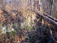
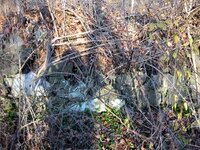
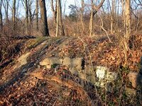
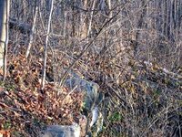
i was out this morning for an hour hunt before going to work...and it was cold! Well I went back to my ATV trails to search the same area where I think was a trash pit. Well I found some more melted metal and some nails. Figured I would search somemore along what i thought was a retaining wall. Now that most of the brush and vegetation has disappeared, it is starting to look like I might have found the foundation I was looking for. It seems that the retaining wall I thought could actually have been part of the foundation. The only crazy thing is this...and this is where you experts are needed. Picture this in your minds. You have a flat area and then there is a drop of about 3 or 4 feet. This drop has all these stones that run for about 50-100 feet in lenght. This is what I think was one side of the foundation. Now at the bottom of this drop is another flat area where I found all the burnt items and broken bricks and shards of pottery and glass and melted metal...you get the picture. In this area I also found the 1862 English penny. Now this flat area has another drop off of again about 3 or 4 feet. There are no stone walls that I can see in this drop off, just dirt. So to draw you a cross section it would look like this:

____________________ A
| stone wall
|
___________________ B
| dirt slope
|
_____________________ C


So section A is the topmost flat area, section B is the area where alot of iron and artifacts are coming from, and section C is another flat area.

Now why would there be a flat area on section A, the stone wall, flat area of section B, the dirt slope and another flat area of section C? I can so far only see the one stone wall/foundation and do not understand why there would be no other stone wall and also why there is sort of a step from one section to another (A to B and B to C) I would think if it was a foundation that it would like like this:

flat area flat area
________________________ ____________________
| < Stone walls > |
|______________________|


Anyway. take a look at my stone wall pics and let me know what you all think....foundation or just retaining wall.

Thanks and I will answer any questions that come up.

Funkman
 

Attachments

  • IMG_1247.JPG
    IMG_1247.JPG
    49.3 KB · Views: 428
  • IMG_1248.JPG
    IMG_1248.JPG
    51.6 KB · Views: 422
  • IMG_1250.JPG
    IMG_1250.JPG
    49.5 KB · Views: 430
  • IMG_1254.JPG
    IMG_1254.JPG
    53.5 KB · Views: 415
section C on the first section should be all the way over to the right connected to the dirt slope. same for second drawing right side flat area
 

Upvote 0
I believe that it is a retaining wall.

A house foundation would of been constructed on the flat area. The stones are not being held together by mortar and if it runs as long as 100' that would be about a 4,000 square foot house. Also, if the wall presently stands at about 3' to the elements, it would not witstand the fluctuation of frost upheavals.

More than likely built for erosion purposes.

Do you think that perhaps water ran along side of wall at one time?

Have you checked the vicinity for other foundations for the main home or structure?

Good luck!

Tony
 

Upvote 0
Tony,

Thanks for the reply. There is a concrete section that is in another area maybe 200 feet away from this area. The concrete has no rebar in it because I scanned over the top of it with the detector and got no hits. I have to investigate this concrete to see if it is just this small section (maybe 3 ft by 5 ft) or if there is more of it buried or it was possibly just dumped there. I know there was a house in these woods from maps dating to as far as 1875 and there was a road also. The road seems to still be there and could be seen from google maps and other aerial photos. A bunch of vegetation and trees (saplings and small newer trees) have grown all over this area so it is hard to determine what was what way back in the 1800's. There are big trees that I could possibly use to see if they made any kind of pattern but doubtful.

Thanks again.

Funkman

BTW, no streams or lakes or anything was in this area on any maps. It is a sloped hill though with flat unsloped areas. These being some of those flat unslope areas.
 

Upvote 0
I agree, it appears to be a retaining wall. Perhaps for growing some type of crop or vine in the area and having a rubbish burn pile nearby for burning the cuttings and household trash?
 

Upvote 0
thanks for the replies. I always thought of a retaining wall but just wanted to make sure. I figured others might have seen similiar things on their hunts and could point me in the right direction. Was hoping it was the foundation but I am still finding more items from that area. The house must have been complteley torn down or the foundation is buried somwhere.

Thanks again

Funkman
 

Upvote 0
Based on the size and location of this thing I would vote for retaining wall too. Do you suppose that it was a dump? Is there a house foundation upwind anywhere? Usually the houses were higher and the dumps were downwind and lower, over stone walls or in depressions or slopes. What kind of forest is this? Hardwoods or pines. The birches come into a field for about 30 years, then pines come in and finally the hardwoods come in (well at least in NH area it seems to work that way). That may help you date the spot or at least find where the house may have stood. Keep us posted on your finds from there it looks very interesting.
 

Upvote 0
enhh said:
....What kind of forest is this? Hardwoods or pines. The birches come into a field for about 30 years, then pines come in and finally the hardwoods come in (well at least in NH area it seems to work that way). That may help you date the spot or at least find where the house may have stood. Keep us posted on your finds from there it looks very interesting.

enhh makes a very good observation and point. We can often get clues to an area and its previous habitaton (or lack of same) from the types of trees and vegetation we encounter. Did you know that vegetation changes occur where there were areas of human population? Many people who seek undisturbed Indian middens will look for slight changes in elevation AND changes in vegetation from the surrounding area. Here in California, the vegetation differences can often be the key to finding an undisturbed site. All these little clues can add up to useful information. As treasure hunters, we are also detectives--using all the sciences to our advantage.

funkman, some of the coolest stuff comes out of trash heaps and burn piles. Hope you find some more great and interesting stuff in those woods.
 

Upvote 0
Early farms would often use stones plowed out of Fields as building material and property boundaries. These can produce lots of good targets as the tended to draw attention from children over time. What kid can resist playing on a low stone wall.
 

Upvote 0
Looks like a line of defense bullworks to me, trench. Possibly a short term garrison was behind the trench.

<<d
_______ b location of garrison area
| c ___________________________________
|_______
|
|_________ a

Ground tapered backup from point a to normal level point b
Point c would have been where infantry would be posted on lookout and during fighting
point d field of view and field of fire

Perhaps this was a hasty constructed bullwork section to oppose an advancing army from a known direction (d) could have been kept low beneath the level of the adjancent lay of the land to give a total surprise factor on the advancing army when they marched into firing range.
 

Upvote 0
Look's like a retaining wall maybe to the road going up to the foundation?The third pic is where I would put my house...Nice and flat....Just a guess though.Any sign of a road in that area??
 

Upvote 0
What the heck. How bout' terrace gardens. If the ground was sloping and rocky the rocks could be stacked on the upper side and a few levels of good soil making for vegies and herbs. The house could be either above or below. I guess you'd had to been there to know for sure. All the replies are good possibilities. Hope you find some goodies that will help you "date" the site.
 

Upvote 0
thanks for all the input my fellow TNeter's. Civilman, yes there is a road but it is way to the right of that photo. It is pretty flat area up there but not sure how much flat area would have been needed for a house back in the 1800's. I know they did not have much stuff and did not need the big houses that they build today. The ATV riders have made a bunch of trails up there and might have dug up areas where the house stood.
I just ran into a couple that have lived up here for a while, since the 40's anyway and they remember the road but they do not know of a house that was there so the house was gone before then. I am starting to wonder if maybe the house burned down and that is why I am finding a lot of burned items. Who knows.

Thanks

Funkman
 

Upvote 0
Well don't know if was a wall or foundation. But there use to be basements like that. Houses were built on stacked rock foundations. Then later owners want a root celler or basement. Not wanting to disturb the house foundations, they would move in from the walls and dig the required depth to get the basement height they wanted.
 

Upvote 0
It looks like a retaining wall to me too.

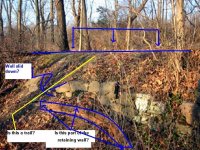
From the picture I would hunt the flat spot where I posted the three blue arrows. It looks like there might have been a trail where I posted the yellow line. I tried to point out how the wall has slid down too.

I’d hunt all the flat spots and trails; children play area and possible parking areas.
 

Attachments

  • Retaining Wall.jpg
    Retaining Wall.jpg
    95 KB · Views: 233
Upvote 0

Top Member Reactions

Users who are viewing this thread

Back
Top