Auburn/colfax ancient riverbeds?

I second this. I still need to find my first nugget detecting!


Sent from my iPhone using Tapatalk
 

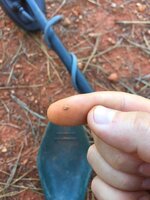
Just found my first piece today! What kinda detector are you using?
 

ImageUploadedByTapatalk1413772173.540087.jpg
 

Thanks guys :) I'd like to find a less-hammered area though, and at least a partner to go with
 

You should have no problem finding gold with it. I want the GMT, and some kind of pulse induction
 

Have you tried the diggins area in Dutch flat & Gold run? Not sure what is public or private these days, but not too long ago it was accessible
 

No I haven't yet, I almost headed out that way though. How can I find out what is public or private property?
 

I'm trying to find a map online of blm of FS land right now and on that might show the ancient riverbed too. For an overlay. If not, a quick drive up to Dutch flat and you can probably ask someone at the store in town for advice
 

I'll have to do that. If you can find an overlay map, or if you make one, id love a copy!!

Are you more of a detectorist or a panner/sluicer?
 

Usually I try to do both if possible having more trouble than I thought with the old maps.
 

If you'd like to go prospect with me sometime, I go up to the auburn/colfax area every weekend for the whole weekend
 

Have you tried the diggins area in Dutch flat & Gold run? Not sure what is public or private these days, but not too long ago it was accessible


I live in Dutch Flat so I can help you out with those questions. Gold Run is either claimed (and has been for years) or its private property. Dutch Flat is nearly all private property and claimed as well. There may be a few places unclaimed, but access to them is through private property and let me tell you that you sure do not want to run into the owners (tweekers with lots of weapons)

If you are looking for a place I know that the dump out around forest hill is open to detect.

Shoot if you have any questions

Cheers,
CalGeo
 

I also go up there beeping on a regular basis. I go up out of dutch flat Last time I was up there I found a huge pile of really big square nails. What they were for or why they came to be where they were is a mystery, but it was smack dab in the middle of a huge hydraulic mining area, so it must have been some important place for so many nails to be there. If anyone wants to go, before the snow flys let me know me and my buddy can probably fit some time together and meet you guys up there. Our schedules don't always work out.
 

I'm trying to find a map online of blm of FS land right now and on that might show the ancient riverbed too. For an overlay. If not, a quick drive up to Dutch flat and you can probably ask someone at the store in town for advice

Checkout Clay Diggins (on this forum) and companies "mylandmatters.org", my guess is you can find just what your looking for.

When you say "ancient river beds" what exactly are you looking for- exposed bedrock from the tertiary or intervolcanic American rivers, old diggins with exposed bedrock, dredge tailings, or dried up riverbeds? "Big Ten's Gold Map" #5 will show the ancient tertiary and intervolcanic rivers in your area as well as historic gold locations, use it in conjunction with a current Forest Service Map. A BLM Surface Management map 30 x 60 minute series will show old mines and dredge tailings as well as provide a key for locating additional topo maps for the area your interested in. There are also some great topo apps for your phone or IPad that show quite a bit and interface with the GPS on your phone for navigation.
 

I also go up there beeping on a regular basis. I go up out of dutch flat Last time I was up there I found a huge pile of really big square nails. What they were for or why they came to be where they were is a mystery, but it was smack dab in the middle of a huge hydraulic mining area, so it must have been some important place for so many nails to be there. If anyone wants to go, before the snow flys let me know me and my buddy can probably fit some time together and meet you guys up there. Our schedules don't always work out.

More than likely the nails are all that remains of the flume and sluices.
 

Behind the dump in foresthill is where I found the little piece :)

And I'd like to find exposed ancient riverbed walls, dried up gold bearing rivers, any of that stuff. I tried detecting exposed bedrock (mineral bar) but no luck. I probably have to hike WAAAAAY back there to find any gold on the exposed bedrock eh
 

Top Member Reactions

Users who are viewing this thread

Back
Top