SoCalDesertFox
Full Member
- Nov 27, 2015
- 120
- 88
- Detector(s) used
- First Texas Search Master DX-3500 (1981)
- Primary Interest:
- Other
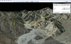
So I'm using Google Earth Pro to look up areas for possible gold hunting sites. I come across what looks like a GREAT site just east of the San Bernardino National Forest, and as I zoom in I notice that it has an Assessor Parcel Number.
So I do the lookup on the parcel - it's current assessed value is listed as "00"

How would I go about determining how much the Gov't would want for the land?
Anyone want to pitch in with me and see if we can't snatch up ~640 acres of prime gold hunting land for really cheap? The parcel just west of it (directly north in the picture, following the riverbed) appears to be up for sale as well with the same assessed value. Make a ~1300 acre mining park for cheap?
So I do the lookup on the parcel - it's current assessed value is listed as "00"

How would I go about determining how much the Gov't would want for the land?
Anyone want to pitch in with me and see if we can't snatch up ~640 acres of prime gold hunting land for really cheap? The parcel just west of it (directly north in the picture, following the riverbed) appears to be up for sale as well with the same assessed value. Make a ~1300 acre mining park for cheap?
Last edited:


