Anyone have an idea as to what this is off the Florida Keys?

huntsman53

Gold Member
Jun 11, 2013
6,955
6,771
East Tennessee
Primary Interest:
Other
Hey Shipwreck Hunters,

Does anyone know what the square item could be at the link below? It is big and just inside the Reef south of Boca Chica Key! Could it be a glitch in Google Maps imaging software, an Image Blocker to hide something that is there or could it be an actual object? I came across it when searching where I use to live and hang out but as usual, I like to search for things in the water when doing so.

https://www.google.com/maps/@24.4860157,-81.6828796,556m/data=!3m1!1e3


Frank
Frank, I honestly don't know for sure. I heard that there were old submarine pens somewhere around Boca Chica. Maybe that is why it is blocked out.
 

Well, it is not Aquarius...it is off Key largo:
https ://www.google.com/maps/place/Aquarius+Reef+Base/@24.950148,-80.453522,11z/data=!4m2!3m1!1s0x0:0x6c5d66c663f4ec8e
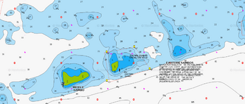
If I have it located correctly on the Navionics app, it appears to be a "Special Use" area. Use it here: Navionics Webapp
download Navionics Eastern Sambos.png
 

Ropes you suck... heh you beat me to it...
I just spent 15 minutes digging out my old keys charts... heh.
 

Ropes you suck... heh you beat me to it...
I just spent 15 minutes digging out my old keys charts... heh.

:) Technology...embrace it!
I can see my Keys charts from here, but this Navionics app is pretty cool.
 

Archie, send me some numbers then, you must have loads you want " looked at" I know I am not on your friends list but " business is business" ha ha.....what is it the Germans say,

Dienst ist Dienst und Schnapps ist schnapps......

Ps....boat ready yet??
 

Last edited:
It's a glitch. Google Maps and Google Earth utilize the same imagery. But you can see earlier imagery on GE and see it is not blocked out. Nor is it blocked out on other aerial imagery sites. Nor is anything marked on any navigational chart.
 

Archie, send me some numbers then, you must have loads you want " looked at" I know I am not on your friends list but " business is business" ha ha.....what is it the Germans say,

Dienst ist Dienst und Schnapps ist schnapps......

Ps....boat ready yet??

Almost...
Little crap now...
Just doing some changes.

Gearing down instead of up... sucks... and I am dragging my feet.

Prolly end up totally gearing down and go do some volunteer work to start the season.
I am usually on water by the first of April... but not this year... or last for that matter. : (

AND getting the FLU OF CRAPOLA sick this year hasn't helped any.
 

Last edited:
Well, it is not Aquarius...it is off Key largo:
https ://www.google.com/maps/place/Aquarius+Reef+Base/@24.950148,-80.453522,11z/data=!4m2!3m1!1s0x0:0x6c5d66c663f4ec8e
If I have it located correctly on the Navionics app, it appears to be a "Special Use" area. Use it here: Navionics Webapp
View attachment 1154859

Ropesfish,

Thanks for the info! I would bet that it is and some other areas around the Sambos are for surveillance of unknown watercraft as protection for Boca Chica Naval Station. I had a feeling that this was possible before I posted but wanted to get some other opinions. If the area is not blocked out on Satellite imagery from other sites, the owners of the sites may have not been required or obligated to block the imagery out for that location. Also, I really don't think it is a glitch in Google's or Google Earth's imagery software due to it being square and having a black border line across the north side.

By the way, I could not get the Navionics Webapp to work! All I got was a blank white screen.


Frank
 

Frank:
The webapp seems to work on my laptop and desktop...not on my Kindle tablet.
The mobile app works very well on my Android phone: Boating iPad (US) | Navionics
Hope you can get it to work...very good bathymetry if you zoom in tight
 

Hi All,
I looked at your link, and as I scanned a bit to the East, I saw these images. Sure looks like several cannons laying there.
North Atlantic Ocean
24.488683, -81.675557
 

Hi All,
I looked at your link, and as I scanned a bit to the East, I saw these images. Sure looks like several cannons laying there.
North Atlantic Ocean
24.488683, -81.675557

They do appear to be a strange "anomalies".

Rather large ?
 

Last edited:
I believe what you are seeing are coral heads or just formations on the edge of the reef. If you look at the scale on the Google Earth screen you will see that they are at least 150' long. Aerial/satellite photography is sometimes deceptive without anything for the eye to use to determine the scale of an object.
 

Top Member Reactions

Users who are viewing this thread

Back
Top