gjb
Sr. Member
- #1
Thread Owner
An Oak Island Reconstruction (cont'd)
A comment made and a question put on another thread prompts me to continue with some further observation on my Oak Island reconstruction. To recap, the five ‘treasure’ maps identify five regularly spaced points in a pattern.

Points A, C and E are identified from Harold T. Wilkins’ maps, points D and F are from Hubert Palmer’s. Point G is the Cave-In Pit.
Hola
The star map is Robot’s idea, but I agree with the principle. I was particularly surprised by it because that same patch of sky features in my thoughts concerning my own collective map, particularly the relationship between the constellations Cygnus and Cassiopeia. You’ll probably already appreciate the similarity between Nolan’s Cross and Cygnus.
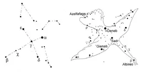
These constellations are circum-polar and the swan is always flying out of the circle, as it were. However, Cassiopeia is generally depicted in one or two specific positions, either as the letter ‘M’ as in Robot’s star map, or the letter ‘W’, usually represented by five stars. The significant point is that with Cygnus aligned much as Nolan’s Cross, Cassiopeia is an ‘M’.
My interest in this part of the sky should then become obvious when looking at the pattern of points identified by the seven maps I believe may apply to Oak Island. My immediate thought was Cassiopeia as a ‘W’.

However, with respect to Nolan’s Cross, this is too low, but I believe that the two Palmer maps indicate that this pattern is to be shifted magnetic north. There’s no indication of how far, unlike Robot’s star map. So, I have simply continued the construction geometrically. This puts Cassiopeia in a better position but it’s still the wrong way up. This leads me to wonder if the rhombus should then be turned upside-down to form a ‘W’.
Nevertheless, I still think the centre of the Rhombus is the most likely location for the deposit.
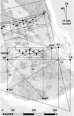
Here, WT is the Welling Triangle, MT is the Mallon Triangle, MP is the Money Pit, and EDR and WDR are the East and West Drilled Rocks. SH is the Sump Hole. The key angles are 30 and 60 degrees.
It only requires one position on this plan to be identified and all the others are immediately placed. This is because it’s constructed from a baseline of 30 rods in length (495 feet, 150.9m) as between the points marked B1 and B3.
In the diagram below, you may just be able to appreciate that there is a relationship between the centre of the rhombus and the mid-point between the Headstone and Cone D of Nolan’s Cross. The two are placed here 75 rods apart (1237.5 feet, 377.2m) at a bearing parallel to the Roadway.
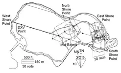
The hope was that I might be able to conduct a survey and check this all out. This might then identify markers at other significant points on the reconstruction,
For example, as this diagram stands, I suggest that there may well be a significant marker (the North Shore Point) lying at 270 feet at a bearing of 300 degrees from Cone C of Nolan’s Cross. Such things are easy to check, and might be considered significant if found.
A comment made and a question put on another thread prompts me to continue with some further observation on my Oak Island reconstruction. To recap, the five ‘treasure’ maps identify five regularly spaced points in a pattern.

Points A, C and E are identified from Harold T. Wilkins’ maps, points D and F are from Hubert Palmer’s. Point G is the Cave-In Pit.
I essentially agree with you gjb. the entry is at another location near by, how far? Turn to your star map for that answer, or go over the nearby ground carefully looking for a out off place marker. OR ??.
Hola
The star map is Robot’s idea, but I agree with the principle. I was particularly surprised by it because that same patch of sky features in my thoughts concerning my own collective map, particularly the relationship between the constellations Cygnus and Cassiopeia. You’ll probably already appreciate the similarity between Nolan’s Cross and Cygnus.

These constellations are circum-polar and the swan is always flying out of the circle, as it were. However, Cassiopeia is generally depicted in one or two specific positions, either as the letter ‘M’ as in Robot’s star map, or the letter ‘W’, usually represented by five stars. The significant point is that with Cygnus aligned much as Nolan’s Cross, Cassiopeia is an ‘M’.
My interest in this part of the sky should then become obvious when looking at the pattern of points identified by the seven maps I believe may apply to Oak Island. My immediate thought was Cassiopeia as a ‘W’.

However, with respect to Nolan’s Cross, this is too low, but I believe that the two Palmer maps indicate that this pattern is to be shifted magnetic north. There’s no indication of how far, unlike Robot’s star map. So, I have simply continued the construction geometrically. This puts Cassiopeia in a better position but it’s still the wrong way up. This leads me to wonder if the rhombus should then be turned upside-down to form a ‘W’.
Nevertheless, I still think the centre of the Rhombus is the most likely location for the deposit.

Here, WT is the Welling Triangle, MT is the Mallon Triangle, MP is the Money Pit, and EDR and WDR are the East and West Drilled Rocks. SH is the Sump Hole. The key angles are 30 and 60 degrees.
It only requires one position on this plan to be identified and all the others are immediately placed. This is because it’s constructed from a baseline of 30 rods in length (495 feet, 150.9m) as between the points marked B1 and B3.
In the diagram below, you may just be able to appreciate that there is a relationship between the centre of the rhombus and the mid-point between the Headstone and Cone D of Nolan’s Cross. The two are placed here 75 rods apart (1237.5 feet, 377.2m) at a bearing parallel to the Roadway.

The hope was that I might be able to conduct a survey and check this all out. This might then identify markers at other significant points on the reconstruction,
For example, as this diagram stands, I suggest that there may well be a significant marker (the North Shore Point) lying at 270 feet at a bearing of 300 degrees from Cone C of Nolan’s Cross. Such things are easy to check, and might be considered significant if found.


 Gib, that was my son trying to locate this site. it happened to coincide with your post, but you may be assured that it wasn't. Keep posting my friend, so far fascinatng.