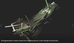
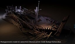
Simply amazing imaging, forget that 'photomosaic' crap!


Based on board the Stril Explorer, an off-shore vessel equipped with some of the most advanced underwater survey systems in the world, the international team of researchers is surveying the sea bed using two Remotely Operated Vehicles (ROVs). One is optimised for high resolution 3D photogrammetry and video. The other is a revolutionary vehicle developed by the survey companies MMT and Reach Subsea.
Surveyor Interceptor ‘flies’ at four times the speed of conventional ROVs and carries an entire suite of geophysical instrumentation, as well as lights, high definition cameras and a laser scanner. In the course of the project it has set new records for both depth (1,800m), sustained speed (over 6 knots), and has covered a distance of 1,250 km
State of the art maritime archaeology expedition conducted in Black Sea | University of Southampton
Last edited:


