Lost Josephine de Martinique

Goldminer

Full Member
Apr 28, 2006
211
107
Las Vegas, Nv
--------------------------------------------------------------------------------
The Josephine de Martinique is supported by tons of historical evidence, as referenced by church and civil archives. The earliest evidence that I have found dates to around 1630’s when Padre Posada was adventuring along the Old Spanish Trail.
The Spanish mentioned that the “Josephine” was the richest gold mine in the world, even richer than Tayopa. Indian labor was used in the mines, and many died as a result of harsh treatment by their masters.
In 1680, the pueblo revolt ended the Spanish occupation for about twenty years. All mines and their evidence were completely concealed.
Around 1868 a man known as John Burke arrived at the stage station at Desert Springs, and began telling Ben Bowen that he knew where “the lost Spanish mine of the Henry Mountains was hidden”. Bowen caught gold fever, and decided to join Burke. They went into Marysvale, Utah, and hired a third man named Blackburn to be camp tender and wrangler. They purchased supplies from a rancher at Blue Valley, and were warned against going into the Henrys. Some years before, an Indian who had worked for the rancher told him as they rode in the mountains, “There is plenty gold up there!”
The three men crossed the headwaters of Crescent Creek and made camp. Burke and Bowen climbed to an outcropping ledge of gold ore in which a shaft had been made long before. They left Blackburn down below with the stock.
The two men broke enough gold-laced quartz from the ledge to fill their pack sacks. When they returned to camp, Blackburn asked where the mine was, and was told, “You can see it from here”, but no further directions were given.
They left the mountains through Penn-Ellen Pass, heading northwest across an unknown desert. This was a mistake, as they thought the desert was flat, but as they began to cross it they discovered a maze of deep canyons. The men suffered from thirst, and ignoring Blackburn’s warning drank from a stagnant pool. Long story short, both Burke and Bowen died shortly afterwards. Blackburn returned many times, but was unable to locate the mine.

In 1900, Edgar T. Wolverton (who was a mining engineer) began to search for the Burke and Bowen diggings, which he assumed was the Lost Josephine. He lived alone in the Henrys for more than twenty years, and explored every inch of the terrain. He found old smelter sites and piles of slag so old that pine trees with more than 100 year rings were growing in them. He found one pit that he estimated to be 175 years old with pieces of melted gold. He also found the remains of a stone furnace and arrastras. Wolverton was an incredible man when it came to communication. In his daily journal which he kept for nearly 21 years, he wrote “Location work done, camp put up, trail opened, mill built. Problems make any work except the most necessary very diffi.” It took him 20 years to build that mill!! His last journal entry of July 21st, 1921 reads, “Found the old Mexican (Spanish) mill today while panning on the hill south of camp. Sack of ore brought down……(illegible)… a very hard day, tired and thirsty”. That was his last entry because he was thrown from his horse and fatally injured.

Before Wolverton, also in 1900, two men Frank Olgean and Al Hainey found in the church archives in Santa Fe, a waybill to a gold mine. Following the waybill, they were led into the lower Henry Mtns. Stone markers were found that led them to a cave where they found on a wall, another waybill to the Josephine. Upon arriving in the Henry’s, Olgean and Hainey found evidence of old mining activity. An old smelter still had slag and Hainey picked up a piece of phonolite, which he did not have assayed right away. Finding no sign of the mine, both men left the area with just samples and pretty colored rocks. Later, Al Hainey had the sample of phonolite assayed, and was astounded when the report came back $50,000 to the ton. Hainey returned to the Henry mtns, and spent considerable time searching, but to no avail. The Lost Josephine was still lost. The last anyone ever saw of Hainey, he was walking back towards Hanksville muttering to himself.
If interest warrants, I will post my own searches for the Josephine later.
 

Howdy Goldminer,

Very interesting, I for one would like to hear more. Are you still actively searching for this mine?

Sincerely,

Infosponge
 

There is solid evidence that the mine is located on Hoyt Peak in the Uinta mountains. Steven Shaffer, author of several books on the spanish in Utah has documented this very well. His book Out of the Dust has the story in a relatively short form, because the book also contains a wealth of information on the Spanish in Utah. His main hunting partner for decades in the mountains of Utah was Gale Rhoades, and his knowledge of the spanish in Utah from research and ground work is amazing. He has another book called "The Lost Josephine Mine" which gives greater detail and pictures of the mine and the area around it. When you see the mine location and the map, you will also be convinced that the Josephine has indeed been found. The Mine found in the Henry's was real and spanish, but not the Josephine.

If you don't have the book "Out of the Dust" I would strongly suggest you get it. I have read it several times, there are incredible stories and spanish treasure leads in there
 

There are two Josephine mines in Utah, one in the Uinta area and one in the Henry mountain area. I have all the documentation that I need.
 

Hi Goldminer,

I have heard of a Josephine mine in Utah, but I haven't heard of two Josephine mines in Utah. Now I really want to hear your story. As far as Steve Shaffer's story, I have my doubts that what he or anybody else found on Hoyt Peak was the Josephine mine. If you decide not to share your story, I understand.

Good luck, and I wish you and yours all the best.

Sincerely,

Infosponge
 

( I will try to post this in several parts with pictures )

In 1993, I was approached by three men from Utah who had been looking for the Lost Josephine for several years. All three had lived in Hanksville and worked in mines nearby. Hanksville is about 40 miles from the search area.
These men had heard that I was a professional and had done research on the Old Spanish Trail in Utah. They came with topo maps and a journal that was absolutely unbelievable.
It seems that they knew someone in Marysvale who knew the Blackburn family, and this journal had been written by the same Blackburn who was the camp tender for Burke and Bowen.
At this time, I knew very little about the Lost Josephine, as I was interested mainly in the Old Spanish Trail. I was shown parts of the journal, and the topos, and given first hand accounts of searches by these men. They seemed very sincere and knowledgeable, and they were familiar with mines and the area. I agreed to spend two weeks camped in the Henry’s with these fellows for a careful search.
We made camp in a piney area at 8,800 ft., and our search area began at over 9,000 ft. The slopes on all sides were nearly vertical, or so it seemed to me. One could not walk without a stick. Quite a bit of the terrain was covered by scrub oak and manzanita. Other areas were very rocky. The flat areas near the creeks were covered with quaky aspens and some very old pines.
I was shown many tree carvings, and Wolvertons mill site, and cabin area, with the mill flume still standing, and the old cabin that had collapsed. His mill had been removed from the area and reconstructed in Hanksville, and the old Spanish arrastras had been removed as well. Still many carvings on the trees could be made out, and plainly indicated an area very near to Wolvertons mill and camp.
We knew from Wolverton’s daily journal that he had found a mill site and some ore from a mine, somewhere south of his camp. Since we knew where his camp was on Straight Creek, we began our search towards the south. Many trees had carvings, and there were some very, very old tree stumps that had been hand cut in the area. After we had left the area of the creek where the pines and aspens were prolific, we started to climb a rather steep hill towards a ridge. Many rocks and very heavy brush covered the hillside. If a mine had been hidden in this area, one would never find it without special equipment.
The journal that had been written by Blackburn stated that he had made camp on Corral Creek when he accompanied Burke and Bowen. We next turned our attention to the Corral Creek area. Again we found many tree carvings that pointed to the area south of Wolverton’s camp. In Blackburn’s journal, we found that he had returned many times to this area searching for the mine that Burke and Bowen had taken ore from. His last trip was in 1911, when he was accompanied by a man whose name began with “R”.
Centering our searches around the creek area, I found a homemade , very old snaffle bit for a mule that had been fashioned from baling wire. On one of the huge aspen trees, we found a carving which read "Blackburn-1911". (quotations mine)
Remembering what the two old prospectors told Blackburn, (“You can see it from here”) we started a search up towards the top of Mount Pennell. Oh brother, what terrain that was!!! The four of us had split up to cover more ground. (I searched along the road) Eventually one of the guys hailed us, and said that he had found something on top of a ridge(groan..). So climb we did.
There at the very end of a ridge point, we found a “coyote hole”, with quartz gangue lying around. (this would be the only quartz we would find in the entire area) Across the top and along one side of “the hole”, was hand-hewn logs supporting the opening. I tied a rope around my waist and a tree and climbed down into the mine. Not far down, there had been a cave-in, and the rock above me was very loose, so I did not stay long.
One of the guys had been searching along one side of the ridge point, when he yelled out that there was more digging in that area. We all moved to that side of the mine entrance, and continued to look for ore samples. What we found was absolutely a treasure hunters dream. Half buried in the soft soil was ………… a large, badly eroded pewter ladle!!!!! Much older than any modern miner would have carried.
 

Part 2
After fourteen years of research and exploration, we went back to make a final attempt to pinpoint the Lost Josephine de Martinique. The Spanish called this famous mine, “the richest gold mine in the world” Armed with geophysical equipment, we went back into the Henry Mtns. in southern Utah for an extended stay. Our base camp was located at 8,000 feet, and the search area is some of the most rugged that I have ever seen in any southwestern state.
We have copies of journals, and I have seen physical evidence of Spanish activity in the immediate area of our search. I have seen old mine workings, arrastras, a smelter, and extremely old tree carvings, along with evidence of earlier searches. The magnetic anomaly detector will pinpoint any iron related outcrop, and the use of geochemical testing can tell us if gold is present within the anomaly.
We returned from the Henry Mtns. battered, bruised, cut and limping, and dismayed.
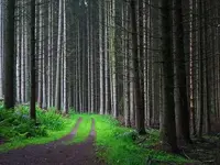
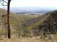
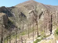
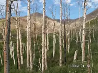
What we encountered was totally unexpected. I remember the area from a few years ago as one of the most beautiful in any of the western states. There was a forest fire there about two years ago, and the destruction was total and devastating to see. I was shocked and deeply saddened to note that everything that I remember was completely gone. All, and I mean everyone of the trees were burned, which means that all of the very old tree markings were destroyed. The old mill site and cabins, the mill flume, everything was gone. In their place was brush, now grown to about seven feet high so thick that you can't see anything from more than 18" away. All the streams are choked with debris that made walking the banks almost impossible. Most of my injuries came from falling in the creeks numerous times because of the debris.
We did take pictures of the area, and we did make a couple of discoveries. The first picture is how I remember the area from my first visit. The next three pictures show the devastation from the fire.
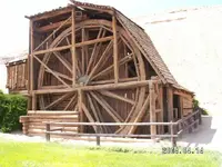
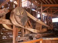
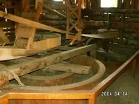
The next set of photos show the actual mill that Ed Wolverton built by himself. It took him 21 years to reach this point. No one can make me believe that Wolverton did not know that the Josephine was nearby. Remember, he had walked these mountains for years. He knew where every single piece of evidence was located. He knew where the Burke and Bowen deposit was, and that it was not the Josephine, he knew where the Spanish arrastras were, and the old smelters location. You don't go to this amount of work on speculation.
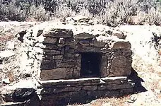
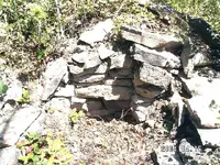
I have saved the best photos for last. One shows a picture of a Spanish smelter in Nevada, and the other shows what we found buried in the brush just a few hundred feet from Wolverton's old mill site.
 

These are the photos of the area.
 

Attachments

  • HM1.jpg
    HM1.jpg
    88.8 KB · Views: 1,124
  • HM2.jpg
    HM2.jpg
    130.3 KB · Views: 1,246
  • HM3.jpg
    HM3.jpg
    152.2 KB · Views: 1,108
  • HM4.jpg
    HM4.jpg
    141.2 KB · Views: 1,053
Here are the pictures of Wolverton's mill. He built this by himself, and hauled that steel mill works up to 8000 feet.
 

Attachments

  • Mill1.jpg
    Mill1.jpg
    124.3 KB · Views: 1,059
  • Mill2.jpg
    Mill2.jpg
    120 KB · Views: 1,008
  • Mill3.jpg
    Mill3.jpg
    70.2 KB · Views: 956
That is an awesome find to say the least. I have hunted the spanish gold cache on Fishlake mountain, and have an extremely promising find. That clue was thanks to my now deceased Grandpa who had lived in Richfield and was kind to the Indians. One gave him some clues, but wouldn't go there himself due to the bad spirits. It is "known" as far as it can be that this gold was buried by the Indians after an uprising against the Spanish. I have also hunted the Cache and mine on Boulder Mountain referenced in the book I mentioned earlier. I will probably be back to either Fishlake or Boulder Mountain here in the next few weeks if the weather holds out. That whole area in itself is a treasure and I love it down there. I look forward to your posts on your find, and am excited for you whether or not it is tha fabled mine. If it makes me rich, I don't care if I find a mine named the pooper scooper, the gold or silver is still just as real...
 

As I wrote above, I have saved the best for last. The first picture is of an intact Spanish smelter in Nevada, and the next is what we uncovered completely buried. We only uncovered the portion that shows in the photo.
 

Attachments

  • SpanishSmelter-Large.jpg
    SpanishSmelter-Large.jpg
    53.9 KB · Views: 3,568
  • Henry2.jpg
    Henry2.jpg
    124.4 KB · Views: 1,071
Final thoughts.
Did Burke and Bowen take gold ore from the Mount Pennell area? Yes! Was it from the Josephine? No, remember Wolverton said, " found the old Mexican(Spanish) mill site ........... on the hill SOUTH of camp". The Burke and Bowen mine is located NORTH of his camp, and quite high above the Spanish arrastras and smelter. Did we find the Burke and Bowen mine? I believe so. It was above Corral Creek, there was a very old shaft, one could see where ore had been knocked off around the entrance to the mine. Wolverton built his mill and camp on Straight Creek. Across from his camp were Spanish arrastras, near the mill was a smelter, nearby were tree carvings indicating a direction to his area. He wrote in his journal that he had found ore south of his camp on a hill side.
Olgean and Hainey had followed a waybill to the Mount Pennell area where they found an old smelter. Hainey found a piece of phonolite that contained gold. There is quite a bit of phonolite in the area.
One last little piece of interesting information. My partner has built an electronic geophysical instrument that will detect magnetic anomalies from a distance. In only one place in the entire area did we get a reading. Standing at the site of Wolverton's mill, we got a reading directly south, up on the hill side!
 

Thank you Goldminer, for sharing your story and great photos! Do you have a copy of the waybill that you would be willing to share? If not, I understand. I wish you all the best, and hope you find what you're looking for on that hillside.

Thanks again!

Sincerely,

Infosponge
 

Goldminer...

There are lots of Josephines. It was fairly common to name your mine after the Empress of the period to show respect. I guess the question is are you referring to the Josephine from the Garcia Waybill?

If so your a long way off. I've spent 3 days in the Josephine this year. 300 feet deep and a long way from the opening. We're damn near to that wooden door...
 

Funny thing about Utah and her lost Spanish mine sites. They go undiscovered for many many years and then one day someone with the right focus comes along and finds true sign still intact form Spanish activities, as though they had just walked away from it yesterday. Upon returning a year or two later, one finds that Mother Nature has completely destroyed the location and sent it away with the ghosts. I have my serious doubts that anyone has entered the Josephine for a long time as the Utes buried and landscaped her long ago. Let us be thankful that the Spanish thought ahead and tunneled a drift out some ways away that the Natives figured was just fine since only the trained eye would ever notice it under it's sleeping capstone.
 

Sorry guys of posting so late in this thread, but I have found it little time ago. I hope someone is still around to have a good conversation.
Lost mines and treasures in Utah attracted my attention the last two years. What make me feel more confortable in my research, were plenty of clues and maps, left by the Spaniards and different others who found and worked those mines and treasures along the past centuries.
I have never been in Utah, but using maps and aerial images and adding the clues from different stories, I believe I'm close to a solve if not solved completely. But this only the future can prove it.

What I found little controversial in the Goldminer's story about Josephine de Martinique of the Henry's Mountains, is the clues given in the story and the place Golminer has researched with his partners. IMO, was logical to find nothing about 9 miles afar from the first story's clues. Maybe they were lured by the research that have done in Straight Creek at the beginning of 20th century.
I believe I have read it well when the story tells: " They crossed Crescend Creek headwaters and made camp ".
If they would traveled another 8-9 miles, I believe they would mentioned that in their story. At that time 8-9 miles was a considerable distance to ride in a difficult terrain. So,IMO the Josephine of Henry's Mountains is close to Crescend Creek headwaters/springs , no more than 3/4 mile afar.
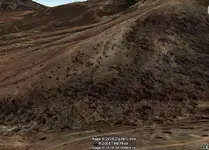
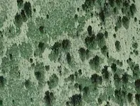
After I used my skills in maps and clues decrypting, I was able to find using GE aerial images,what could be the lost Josephine in the Henry Mt.
Here is a photo of it. Enjoy

Josephine of Henry's Mt.jpg
 

Last edited:

Top Member Reactions

Users who are viewing this thread

Back
Top