Last edited:
Navigation
Install the app
How to install the app on iOS
Follow along with the video below to see how to install our site as a web app on your home screen.
Note: This feature may not be available in some browsers.
More options
You are using an out of date browser. It may not display this or other websites correctly.
You should upgrade or use an alternative browser.
You should upgrade or use an alternative browser.
Parajes donde vararon los navíos de la flota del año 1733
- Thread starter Jolly Mon
- Start date
theseeker
Sr. Member
- Mar 4, 2009
- 345
- 139
- Detector(s) used
- White's Surf PI Pro Dual Field/Minelab Sovereign Elite/Goldbug II/Goldbug Pro
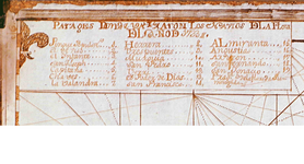
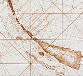
Jolly Mon, that chart & legend show 19 shipwrecks. The State of Florida Spanish Galleon Trail Site with the map of the Locations of the 1733 Spanish Plate Fleet Shipwrecks only list and show 13 shipwreck locations. Have the other 6 shipwreck sites listed on your map and legend been found and worked? I'm sure they have been stumbled upon by someone?
- Thread starter
- #3
Jolly Mon, that chart & legend show 19 shipwrecks. The State of Florida Spanish Galleon Trail Site with the map of the Locations of the 1733 Spanish Plate Fleet Shipwrecks only list and show 13 shipwreck locations. Have the other 6 shipwreck sites listed on your map and legend been found and worked? I'm sure they have been stumbled upon by someone?
Yes, this chart shows wrecks the other lacks. This chart comes directly from the Indies Archives: MP-SANTO DOMINGO,862. All the charted wrecks were pretty thoroughly worked by the Spanish in the aftermath of the original event. Whether or not they have all been found and worked in modern times is a question I cannot answer. I do know that a goodie or two is still occasionally found near the known wreck sites.
Last edited:
mad4wrecks
Bronze Member
- Dec 20, 2004
- 2,263
- 109
- Detector(s) used
- Aquapulse, DetectorPro Headhunter, Fisher F75
- Primary Interest:
- Shipwrecks
The Spanish actually recovered more treasure than was listed on the manifests, which resulted in many trials and court marshals. My understanding is the San Fernando is the only 1733 shipwreck that has not been found.
- Thread starter
- #5
The Spanish actually recovered more treasure than was listed on the manifests, which resulted in many trials and court marshals. My understanding is the San Fernando is the only 1733 shipwreck that has not been found.
Interestingly, it seems Bob Marx had never seen the above chart. Reading through Shipwrecks of the Americas, it is clear he had access to at least 3 salvors charts, yet he states on page 214: "San Fernando is not mentioned in the documents or shown an any charts as being lost, but was probably mentioned by its alias, if it had one."
San Fernando is listed as ship # 18 on the above chart... it looks like to me it should be very, very close to Duck Key.
In any event, someone is after it: The 1733 Treasure Fleet Shipwreck, the San Fernando
- Thread starter
- #6
This seems WAY too clear an outline to be an 18th century ballast pile, it is probably just an image glitch...no modern wrecks are charted here:
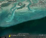 The image date is 12-23-1999...the red line is 116 feet
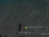 This is a close-up of the same image...
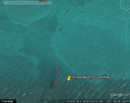 Here is the same location...the image date is 12-14-2008
I am sure it's nothing, but if you are out diving for bugs in the area...
 The image date is 12-23-1999...the red line is 116 feet
 This is a close-up of the same image...
 Here is the same location...the image date is 12-14-2008
I am sure it's nothing, but if you are out diving for bugs in the area...
Vox veritas
Bronze Member
- Aug 2, 2008
- 1,078
- 271
- Primary Interest:
- All Treasure Hunting
Yes, this chart shows wrecks the other lacks. This chart comes directly from the Indies Archives: MP-SANTO DOMINGO,862. All the charted wrecks were pretty thoroughly worked by the Spanish in the aftermath of the original event. Whether or not they have all been found and worked in modern times is a question I cannot answer. I do know that a goodie or two is still occasionally found near the known wreck sites.
Jolly, there is some mistake. MP (Mapas y Planos) Santo Domingo only reaches the number 845. No 1733's year reference in this
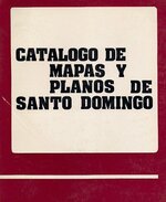 catalog.
- Thread starter
- #8
Jolly, there is some mistake. MP (Mapas y Planos) Santo Domingo only reaches the number 845. No 1733's year reference in thisView attachment 788824 catalog.
Here is the link: MINISTERIO DE EDUCACIÓN, CULTURA Y DEPORTE - Portal de Archivos Españoles
I just typed "naufragios" into the search box...
clicked on "mapas y platas" under the heading, "Archivo General de Indias"...
and it comes up as the last map on the list.
Make sure you have "Registros digitalizados" selected in the original "Búsqueda Sencilla"...
I am far from an expert on the PARES system, but I have fun playing around with it...
I just wish I could read Spanish !!! LOL
Vox veritas
Bronze Member
- Aug 2, 2008
- 1,078
- 271
- Primary Interest:
- All Treasure Hunting
Here is the link: MINISTERIO DE EDUCACIÓN, CULTURA Y DEPORTE - Portal de Archivos Españoles
I just typed "naufragios" into the search box...
clicked on "mapas y platas" under the heading, "Archivo General de Indias"...
and it comes up as the last map on the list.
Make sure you have "Registros digitalizados" selected in the original "Búsqueda Sencilla"...
I am far from an expert on the PARES system, but I have fun playing around with it...
I just wish I could read Spanish !!! LOL
Mystery clarified. The number 862 is the bundle which was the document, from section Santo Domingo.
Southern_Digger
Hero Member
- May 21, 2012
- 573
- 222
- Detector(s) used
- Minelab Explorer and Excalibur; Tesoro Tejon; Fisher 1265-X; Garrett Master Hunter; White's Coinmaster; In closet: Bounty Hunter and Relco
- Primary Interest:
- Other
Jolly, there is some mistake. MP (Mapas y Planos) Santo Domingo only reaches the number 845. No 1733's year reference in thisView attachment 788824 catalog.
Even our own National Archives Cartographers Division does not catalog every map they have. I learned that quickly when I visited them for Florida maps and they pulled out volumes of unregistered maps--many of them the original field maps from which were used to create the catalogued maps.
Southern_Digger
Hero Member
- May 21, 2012
- 573
- 222
- Detector(s) used
- Minelab Explorer and Excalibur; Tesoro Tejon; Fisher 1265-X; Garrett Master Hunter; White's Coinmaster; In closet: Bounty Hunter and Relco
- Primary Interest:
- Other
This seems WAY too clear an outline to be an 18th century ballast pile, it is probably just an image glitch...no modern wrecks are charted here:
I am sure it's nothing, but if you are out diving for bugs in the area...
Looks to me like another adventure for the "Shipwreck Men..."
pvet7521
Full Member
- Dec 30, 2010
- 121
- 34
- Detector(s) used
- Whites, Aquapulse, Grometrics
- Primary Interest:
- Shipwrecks
Spanish map
Marty Meylach included a small copy with his book, I got a copy of the map from the British Museum. I think there a a few 33s still out there. I don't think Poda De Dios was ever found and I know La Floridina was never located, it most likely sank in deep water off Lower MacacumbeLooks to me like another adventure for the "Shipwreck Men..."
huntsman53
Gold Member
When I lived in the Florida Keys, a friend told me about a story of an old fisherman that went out fishing at night in the area around Duck Key. He had a bad tendency to spend more time drinking than he did fishing and one night after having drank too much while out on the water, he awoke the next morning somewhere North (on the Gulf side) of Duck Key on a sandbar. He noticed quite a few rectangular bars which due to their' color he thought was some sort of ballast stone, so he picked up a few of them and took them home to use as ballast in the future. Many years later, he was selling one of his' boats to a gentleman that just happened to see the so-called ballast stones which weighed in around 75 pounds each. He inquired as to what they were and since the old fisherman did not know, the potential customer asked if he could take one with him to have it analyzed. Well, since the potential customer never returned, the old fisherman checked the so-called ballast stones and found them to be Silver. He went out many times on the Gulf side of the Keys North of Duck Key but could never find the sandbar again as they are constantly shifting with the tides. Rumor has it, that the Silver Bars were similar to the ones Mel Fisher found when salvaging the Santa Margarita and Atocha wrecks. While many Treasure Salvors repeatedly look on the south or Atlantic side of the Florida Keys for Spanish shipwrecks sunk by Hurricanes, it is quite conceivable that some of the wrecks were actually carried between or even across some of the smaller Keys and ended up on the Gulf side of the Florida Keys. If the above story is true and my friend was good at picking up on whether a story was true or not as he found a lot of Spanish Pieces of Eight before, during and after the time that I knew him, then I would be looking North of Duck Key. This is a hard area to navigate with any boat or ship with a good draft as there are lots of Coral heads and outcroppings near the surface and lots of sharks. I remember one place that my friend found a lot of Spanish Pieces of Eight where the water is very shallow on the Atlantic side and due to such, Hurricanes blew many pieces of Spanish Pieces of Eight into and across the sand dunes and even into the water on the Gulf side of the Keys.
Frank
Frank
Last edited:
Users who are viewing this thread
Total: 2 (members: 0, guests: 2)
