The China Bar Treasure?

isaiahburns

Tenderfoot
Apr 29, 2020
6
4
Oregon
Primary Interest:
All Treasure Hunting
Has anyone heard any information about this treasure?

The story goes like this: "Located just below the mouth of Salt Creek was a mining camp called China Bar, named such because it was worked by Chinese prospectors. The Indians, who had long called the area home, were unhappy with these intruders and an ongoing war was taking place between the two factions. During one vicious attack, the miners fled with their gold to a cave near China Bar but were chased down by the Indians and killed. Their gold is still said to be hidden in the cave, which has not been located. China Bar is extremely remote, located on logging roads deep in the mountains in an area called Scuzzy Creek in Fraser Canyon.”

That passage is from the page Legends of America, here: https://www.legendsofamerica.com/or-moretreasures/

I'm very interested in researching this one because it's close to where I live, but I cannot find any mention of the story before this page was published.
 

China Bar isn't remote as the location is accessible by Hwy #1-though it might should far away remote to you. But if were as stated "because it's close to where I live" you would know this already.

This link of treasures from Oregon tales/stories-not even in the same state or country-so say what???

Here's a kind of a fact page on the location in general.

https://en.wikipedia.org/wiki/Fraser_Canyon

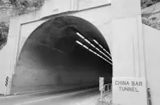
Here's the tunnel entrance picture.

6A864495-221B-49B6-838A-12957634431E_4_5005_c.jpeg

Here's a good read on the Fraser Canyon war.

https://www.thecanadianencyclopedia.ca/en/article/fraser-canyon-war

Actual facts:

The Fraser Canyon War (a.k.a. the “Fraser River War” and the “miners’ war”) was a war waged by mainly white Americangoldminers against the Nlaka’pamux Indigenous people of the Fraser Canyon in the summer of 1858. The war began when the miners, arriving as part of the Fraser River Gold Rush in June 1858, perceived scattered Nlaka’pamux attacks in defense of their territories as a coordinated effort to drive them by force from their claims. Driven by a hunger for gold and a sense of entitlement to Indigenous peoples’ territories and resources, American miners formed military companies and carried out violent attacks on Nlaka’pamux communities. The war ended on 21 August 1858, when the Nlaka’pamux and miners called a truce. Under threat of further violence, the Nlaka’pamux agreed to grant miners access to their territories and resources, bringing the immediate conflict to a close. The conflict bears resemblance to the Chilcotin War of 1864, another Indigenous-newcomer conflict in the colonial history of British Columbia.

"
During one vicious attack, the miners fled with their gold to a cave near China Bar but were chased down by the Indians and killed."

Here are some of what happened-fact.
As the summer wore on, miners disrupted Nlaka’pamux communities. Some of the men committed acts of sexual violence against Nlaka’pamux women, euphemistically referred to in a letter by an HBC official as “insulting there [sic] women.” The men mined gold without consulting Nlaka’pamux community leaders for permission, and threatened violence when challenged.

So the link you posted up is a true embellishment of facts, sorry to tell you that the remote isn't remote-just another written article snippet from a no nothing author.
 

Last edited:
The “China Bar” referred to in the legend synopsis is likely one of several that once held that name on the North Umpqua River, near the mouth of Salt Creek. There is a nearby area, over the hills to the east of Sutherlin, called Fraser Canyon. During the placer mining era on the North Umpqua, there were a few routes that joined both areas. With the current network of logging roads, one would be hard pressed to find the original routes.

Back to the treasure legend, many miners lost their fortunes in similar ways. Also a cave could be something as simple as an overhang large enough to keep one out of the weather.

Looking into the mining history of the North Umpqua, and Douglas County could shed a bit more light on this.

Time for more coffee.
Skuzzy Creek/Fraser Canyon/China Bar
Show me where in the State of Oregon and the year of ref.
Like I stated I seriously doubt it was the area you are referring to
 

Skuzzy Creek/Fraser Canyon/China Bar
Show me where in the State of Oregon and the year of ref.
Like I stated I seriously doubt it was the area you are referring to

Do your own research. There is more than one Fraser Canyon in the world. More than a dozen Salt Creeks just in Oregon. And hundreds of places in the west that once held the name of China Bar.

Time for more coffee.
 

Do your own research. There is more than one Fraser Canyon in the world. More than a dozen Salt Creeks just in Oregon. And hundreds of places in the west that once held the name of China Bar.

Time for more coffee.
I'm not talking about the world so lets narrow the search pattern here to the subject at hand.
Here is a list of rivers.
https://en.wikipedia.org/wiki/List_of_rivers_of_Oregon
It lists 1 Salt creek ( though the original topic was referring to Skuzzy Creek)
Salt flows into the Middle Fork Williamette
https://en.wikipedia.org/wiki/Salt_Creek_(Middle_Fork_Willamette_River_tributary)

Douglas County one ref: Clearwater River Chinese Massacre. Douglas County.The Clearwater River, a 15 mile-long tributary of the North Umpqua River approximately 50 miles east of Roseburg, was the site of the massacre. Approximately 30 Chinese were killed in 1877 by a band of Native Americans. Reference: Penner 1990: 27.

One Ref: for China Bar (besides the bar that was bombed awhile back)
China Bar. Josephine County.
China Bar is approximately one half mile north of where Mule Creek joins the Rogue River. China Bar was the location of a community of Chinese placer miners who worked the area from the 1860's to the 1880's. The bar is named after Chow Long, an early Chinese placer miner. China Bar is within the Rogue National Wild and Scenic River. Reference: “Rogue River Float Guide” 2004; U.S.G.S. quadrangle, 7.5’ series, Kelsey Peak, Oregon, 1998.

Yet to find this "Fraser Canyon and Skuzzy Creek" in the State of Oregon.
You claim there is so why not help debunk my theory on debunking the original story.
 

Wikipedia? Really? How about some real research. Put some time in photocopying maps, diaries, letters, and other records.

Of those I can remember, there is one Salt Creek in Polk County, one in Marion County, two in Lane County (including the one cited in Wikipedia), three in Douglas County, one in Clatsop County, one formerly named in Lake County. Those are the few I can remember off the top of my head.

The name “China Bar” typically referred to where the Chinese were working at the time. Few stuck as place names for more than a few years. There were no less than four on the North Umpqua, six on the South Umpqua, and no less than 10 on the gold rich Rogue River. Cow Creek, a tributary to the South Umpqua may have had a few, since a few groups of Chinese worked old placers for a few years.

Fraser Creek, in Douglas County, east of Sutherlin, flows through what is identified on older maps as Fraser Canyon. Not much of a Canyon, in my opinion.

Skuzzy Creek? Do not know that one. Likely a feature name that did not survive official naming of places and features. If it existed, it may be one of the many unnamed creeks in the area.

The cave mentioned in the tale is likely a large overhang deep enough to
get out of the weather. There are many such features in the region.

Wikipedia is for people too lazy to do research.

I do not know if the tale referred to in the original post is accurate or true, but it does resemble several tales that can be found in local newspapers. I have found many such stories on microfilm at libraries and historical societies.

Time for more coffee.


I am wondering if Skuzzy creek could have, over the years, had the name altered to Spuzzum..

https://en.wikipedia.org/wiki/Spuzzum

Okay it is wiki.. and we all know how that works.. :laughing7:

And there was a Skuzzy Bridge which lead to China Bar on the Fraser River in B.C...

https://albertaonrecord.ca/is-whyte-297

Some more information to toss into the mix

Micheal
 

There is also a China Bar in Wallowa County along the Snake river in northeastern Oregon. A massacre of Chinese miners also took place there River and stream names are a dime a dozen. Within 16 miles of my home in Union County I know of two "Mill Creek"s, one within a mile of my house. And I think there are a few more within the county boundaries.

Good luck on your research!
 

Wikipedia? Really? How about some real research. Put some time in photocopying maps, diaries, letters, and other records.

Of those I can remember, there is one Salt Creek in Polk County, one in Marion County, two in Lane County (including the one cited in Wikipedia), three in Douglas County, one in Clatsop County, one formerly named in Lake County. Those are the few I can remember off the top of my head.

The name “China Bar” typically referred to where the Chinese were working at the time. Few stuck as place names for more than a few years. There were no less than four on the North Umpqua, six on the South Umpqua, and no less than 10 on the gold rich Rogue River. Cow Creek, a tributary to the South Umpqua may have had a few, since a few groups of Chinese worked old placers for a few years.

Fraser Creek, in Douglas County, east of Sutherlin, flows through what is identified on older maps as Fraser Canyon. Not much of a Canyon, in my opinion.

Skuzzy Creek? Do not know that one. Likely a feature name that did not survive official naming of places and features. If it existed, it may be one of the many unnamed creeks in the area.

The cave mentioned in the tale is likely a large overhang deep enough to
get out of the weather. There are many such features in the region.

Wikipedia is for people too lazy to do research.

I do not know if the tale referred to in the original post is accurate or true, but it does resemble several tales that can be found in local newspapers. I have found many such stories on microfilm at libraries and historical societies.

Time for more coffee.

Hi, sorry for the late reply, I haven't logged into this forum in a minute. I was researching this treasure rather meticulously last month, but hit some dead ends and decided to set it to the side for awhile. I'm brand new to the world of treasure hunting, so my research skills are yet to be thoroughly developed.

I've found a couple of old diary entries, letters, and newspaper clippings that related to some similar battles between Chinese miners and Native Americans along the rogue river, but nothing that supported the notion of a lost treasure. Would you happen to have any specific examples of evidence or stories that backs up the original LegendsofAmerica post?
 

The “Legends of America” entry is too vague to be of any use to a researcher. It lacks detail, and resembles far too many tales attributed to the area. Some may have some validity, most are just tales that were written to fill space in a newspaper or other periodical. I find that the tales of the past few hundred years that may have enough detail to warrant research come from diaries, family histories, and similar writings.

I wish you well on this project. Many early miners of the region lost their poke for a long list of reasons. Theft, murder, native attack, and memory are but a few.

Time for more coffee.
 

Hello fellow hunters,
I have two possible sites for your legend...Salt Creek is a small, northern tributary of Cow Creek in Douglas County. This particular area was worked by the Chinese labor force, building the railroad for the gold rush at the time. The mouth of salt creek, empties into Cow Creek and has a large "bar". This could be what is known as "china bar" if it was a campsite for awhile, although not officially on any map.
The other area is known as "China Ditch" in Douglas county, near Myrtle Creek. I have heard similar legends/tales coming from that area of the county as well.
 

This is an interesting article about Archaeologists trying to save Chinese mining sites in Oregon.
https://www.opb.org/news/article/oregon-chinese-mining-sites-archaeology/

If there is a lost treasure of Chinese mined gold in Oregon it might be found by Archaeologists and their volunteers.

Here is a GPS location list of Chinese places in Oregon.
https://ochalp.blogspot.com/2014/08/gps-location-of-chinese-places.html

Here is page about Oregon Chinese heritage
https://www.oregonschineseheritage.com/2017/08/josephine-county.html
 

There are china bars alover the west costal states in gold areas. The chinese were not treated well andspent lots of time on rivers below the avtive placer mining areas eking out a living on the "dust" to fine for the other miners to bother with which they tended to hide so it could not be stolen from them. I've heard several "true" stories of secret lost chinese gold on in the mother lode in Ca which i'm not going into here..
 

Have you ever watched "Gold Trails and Ghost towns"? type the name in and add "China Bar", it comes up with a few episodes that might help you. Also there is info in these Journals. https://www.ashcroftcachecreekjourn...lourishes-in-the-early-days-of-the-gold-rush/
I just typed Scuzzy Creek into Google, it comes up as "Scuzzy Creek/Boston Bar, BC. Rec Site/Trails

Driving Directions: From Boston Bar cross the Fraser River towards North Bend. Cross the train tracks and turn left on Green Ranch Road. Drive 12.5 km on the Forest Service Road to the site.
Access to this site is very limited. Scuzzy Creek FSR is in poor condition with frequent wash outs
Good luck.
 

Last edited:

Top Member Reactions

Users who are viewing this thread

Back
Top