deepskyal
Bronze Member
- Joined
- Aug 17, 2007
- Messages
- 1,925
- Reaction score
- 63
- Golden Thread
- 0
- Location
- Natrona Heights, Pa.
- Detector(s) used
- White's Coinmaster 6000 Di Series 3, Minelab Eq 600
- Primary Interest:
- Metal Detecting
- #1
Thread Owner
Here's one for you guys i gave up on.
It is well documented so it is true, I found the records at the Pittsburgh Historical Society which confirmed their existance.
My memory isnt what it used to be but it goes something like this.
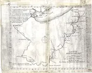
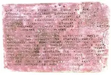
Back about 1690, whoever the King of France was, sent men on a mission to mark off territory in Pennsylvania for France.
These markers were lead plates with the declaration that this property belongs to King so and so...etc. and so forth.
I believe it was 4 plates burried along the Allegheny river. One was found near Aliquippa I think, which used to be an Indian Village. The guy was actually melting it down for fishing sinkers, not knowing what it was or it's historical value.
I can't think of 2 of the other places, you'd have to go back to the historical society for that.
One was burried by the Indian God Rock. That, the rock, is up towards Franklin, Oil City area.
It's a pretty big rock with all kinds of neat Indian signs chiseled into it, and lots of older engravings from people over the years. It seems to have been a very popular swimming hole. The Indian signs are better visable when the rock is wet, viewed from a canoe.
I'm assuming..and you know what happens when you assume,..that the Indian God Rock probably shifted some over several hundred years.
I bought my very first metal detector with this in mind. The value of that lead plate today would be priceless.
I bought snorkeling equipment, extended my Md cord to go under water so I could explore the base of the rock.
First off....the current in the river there is very strong. Not very deep though. I was lucky to be able to stand in waiste deep water without getting pushed down stream.
Second is the railroad, or where the railroad used to be. How much of that has eroded down over the hill to bury the lead plate on the land side of the rock?
And lastly...maybe someone found it and just never said a word. I don't recall the dimensions of the lead plate but it has to be somewhat significant if the King intended them to stay as his property markers.
I used to camp along the river back then but the last time I was in the area I saw they now have the old rail bed blocked off to cars and it's part of a hiking/biking trail I think. Probably a few expensive cabins jammed in there for good measure.
I don't know how anyone would go about recovering such a relic....but there's that chance it could still be there. The God Rock still is there.
Al


