Harry Pristis
Bronze Member
- Joined
- Feb 5, 2009
- Messages
- 2,353
- Reaction score
- 1,294
- Golden Thread
- 0
- Location
- Northcentral Florida
PALEO-INDIANS IN FLORIDA
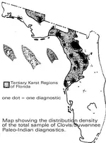
In 1983, Jim Dunbar and Ben Waller published a distribution map and interpretation of the paleo-Indian sites in Florida.
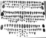
Dunbar and Waller mapped finds of diagnostic Paleo-Indian artifacts. These "diagnostics" are "...Clovis, Suwannee, or Simpson projectile points and carved ivory foreshafts or pins." (Butcher-marked bone of mammoth, horse, and giant tortoise were not included because there is evidence that these now-extinct animals lived on into a later period and may have been hunted by early Archaic Indians.)
It is clear that Florida Paleo-Indians favored the two karst regions of the state. "Karst" is a geological term referring to near-surface, highly eroded limestone characterized by erosional features such as sink-holes, caves, fissures, and deeply-incised stream-channels.
The isolated region (map) on the Florida-Alabama border is an area of uplifted limestone which is the toe of the Chattahoochee Anticline.
The larger karst region is a result of the Ocala Uplift, a crustal movement which took place a few tens of millions of years ago. Today (just as 12,000 years ago), forty-million-year-old limestone is exposed at the surface in this region. Limestone of the same age (Late Eocene) remains deeply-buried in other parts of the state.
Dunbar and Waller suggest that Paleo-Indians favored these karst regions for two reasons: 1.) for access to fresh water through sink-holes and other karst features; and 2.) for access to exposures of chert (for tool-making) which occurs within the exposed limestone.
Adapted from: James S. Dunbar and Ben I. Waller, A DISTRIBUTION ANALYSIS OF THE CLOVIS/SUWANNEE PALEO-INDIAN SITES OF FLORIDA--A GEOGRAPHIC APPROACH (in) The Florida Anthropologist, Volume 36, Nos. 1-2, 1983.
--------Harry Pristis
Upvote
0


 Interesting !
